Burra geodata
Burra (South Australia) is a populated place; located in Australia in Australia/Adelaide (GMT+10.5) time zone. With population of 1,149 people, there are 3644 cities with bigger population in this country. Compared to other cities in Australia, 51.8% of cities are located further ↓South; 76.8% of cities are located further →East and 93% of cities have lower elevation than Burra. Note1


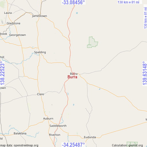
Burra GPS coordinates[2]
33° 40' 18.156" South, 138° 55' 42.06" East
| Map corner | latitude | longitude |
|---|---|---|
| Upper-left | -33.08456°, | 138.22523° |
| Center: | -33.67171°, | 138.92835° |
| Lower-right: | -34.25487°, | 139.63148° |
| Map W x H: | 130.1×130.1 km | = 80.8×80.8mi |
| max Lat: | -10.58257° ⇑48.2% North |
| Burra: | -33.67171° |
| min Lat: | ⇓51.8% South -43.31423° |
| min Long | Burra | max Long |
| 113.53327° | 138.92835° | 153.61246° |
| W 23.2%⇐ | ⇒76.8% E |
Elevation
Elevation of Burra is 472 m = 1549 ft, and this is 350 m = 1148 ft above average elevation for this country.
| Max E: |
1715 m = 5627 ft | 7% |
| Burra | 472 m 1549 ft | |
| Avg. | 122 m = 400 ft | |
Min E: |
-2 m = -7 ft | 93% |
See also: Australia elevation on elevation.city.
Geographical zone
Burra is located in South temperate zone (between Tropic of Capricorn and the Antarctic Circle). Distance of this Southern Tropic circle is 1138 km =707.1 mi to North.| Distance of | km | miles | from Burra |
|---|---|---|---|
| Equator | 3743.9 | 2326.4 | to North |
| Tropic Capricorn | 1138 | 707.1 | to North |
| Antarctic Circle | 3657.2 | 2272.5 | to South |
| South Pole | 6263.1 | 3891.7 | to South |


Nearby cities:
15 places around Burra: (largest is in red/bold)
• Auburn
45.4 km =28.2 mi,  209°
209°
• Balaklava
71.1 km =44.2 mi,  222°
222°
• Cadell
87.3 km =54.2 mi,  117°
117°
• Clare
34.4 km =21.4 mi,  238°
238°
• Crystal Brook
75.5 km =46.9 mi,  298°
298°
• Eudunda
58 km =36 mi,  165°
165°
• Gladstone
69.6 km =43.2 mi,  310°
310°
• Hamley Bridge
79.6 km =49.5 mi,  196°
196°
• Jamestown
59.9 km =37.2 mi,  329°
329°
• Kapunda
74.2 km =46.1 mi,  180°
180°
• Koomooloo
51.6 km =32.1 mi,  75°
75°
• Laura
79.4 km =49.3 mi, 312°
• Peterborough
78.2 km =48.6 mi,  354°
354°
• Riverton
56.3 km =35 mi, 197°
• Truro
84 km =52.2 mi, 167°
Sources, notices
• [Note1] Compared only with cities in Australia existing in our database
• [Src1] Map data: © OpenStreetMap contributors (CC-BY-SA)
• [Src2] Other city data from geonames.org with taken over terms of usage.
• [Src3] Geographical zone / Annual Mean Temperature by Robert A. Rohde @ Wikipedia
