Coondle geodata
Coondle (Western Australia) is a populated place; located in Australia in Australia/Perth (GMT+8) time zone. With population of 673 people, there are 4375 cities with bigger population in this country. Compared to other cities in Australia, 69.7% of cities are located further ↓South; 91% of cities are located further →East and 80.9% of cities have lower elevation than Coondle. Note1


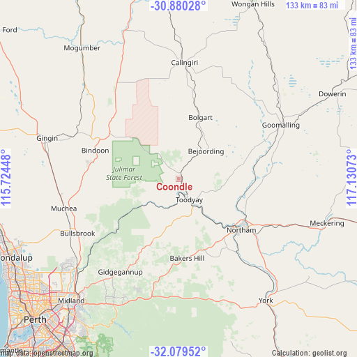
Coondle GPS coordinates[2]
31° 28' 54.552" South, 116° 25' 39.36" East
| Map corner | latitude | longitude |
|---|---|---|
| Upper-left | -30.88028°, | 115.72448° |
| Center: | -31.48182°, | 116.4276° |
| Lower-right: | -32.07952°, | 117.13073° |
| Map W x H: | 133.3×133.3 km | = 82.8×82.8mi |
| max Lat: | -10.58257° ⇑30.3% North |
| Coondle: | -31.48182° |
| min Lat: | ⇓69.7% South -43.31423° |
| min Long | Coondle | max Long |
| 113.53327° | 116.4276° | 153.61246° |
| W 9%⇐ | ⇒91% E |
Elevation
Elevation of Coondle is 192 m = 630 ft, and this is 70 m = 230 ft above average elevation for this country.
| Max E: |
1715 m = 5627 ft | 19.1% |
| Coondle | 192 m 630 ft | |
| Avg. | 122 m = 400 ft | |
Min E: |
-2 m = -7 ft | 80.9% |
See also: Australia elevation on elevation.city.
Geographical zone
Coondle is located in South temperate zone (between Tropic of Capricorn and the Antarctic Circle). Distance of this Southern Tropic circle is 894.5 km =555.8 mi to North.| Distance of | km | miles | from Coondle |
|---|---|---|---|
| Equator | 3500.5 | 2175.1 | to North |
| Tropic Capricorn | 894.5 | 555.8 | to North |
| Antarctic Circle | 3900.7 | 2423.8 | to South |
| South Pole | 6506.6 | 4043 | to South |


Nearby cities:
15 places around Coondle: (largest is in red/bold)
• Bakers Hill
29.6 km =18.4 mi,  174°
174°
• Bindoon
33.1 km =20.6 mi,  288°
288°
• Chidlow
44.6 km =27.7 mi,  199°
199°
• Chittering
33 km =20.5 mi,  272°
272°
• Gidgegannup
37.9 km =23.5 mi,  216°
216°
• Goomalling
42.7 km =26.5 mi,  62°
62°
• Lower Chittering
31.6 km =19.6 mi,  249°
249°
• Morangup
24.5 km =15.2 mi,  211°
211°
• Muchea
44.6 km =27.7 mi,  255°
255°
• Northam
29.9 km =18.6 mi,  128°
128°
• Pearce
44 km =27.3 mi,  242°
242°
• Toodyay
8.4 km =5.2 mi,  153°
153°
• West Toodyay
5.8 km =3.6 mi,  190°
190°
• Wooroloo
37.4 km =23.2 mi, 196°
• Wundowie
31.4 km =19.5 mi, 188°
Sources, notices
• [Note1] Compared only with cities in Australia existing in our database
• [Src1] Map data: © OpenStreetMap contributors (CC-BY-SA)
• [Src2] Other city data from geonames.org with taken over terms of usage.
• [Src3] Geographical zone / Annual Mean Temperature by Robert A. Rohde @ Wikipedia
