Worrolong geodata
Worrolong (South Australia) is a populated place; located in Australia in Australia/Adelaide (GMT+10.5) time zone. With population of 895 people, there are 3982 cities with bigger population in this country. Compared to other cities in Australia, 87.7% of cities are located further ↑North; 75.5% of cities are located further →East and 55.4% of cities have lower elevation than Worrolong. Note1


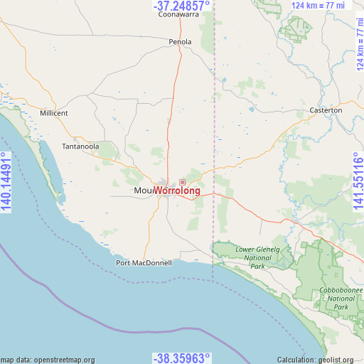
Worrolong GPS coordinates[2]
37° 48' 22.284" South, 140° 50' 52.908" East
| Map corner | latitude | longitude |
|---|---|---|
| Upper-left | -37.24857°, | 140.14491° |
| Center: | -37.80619°, | 140.84803° |
| Lower-right: | -38.35963°, | 141.55116° |
| Map W x H: | 123.5×123.5 km | = 76.7×76.7mi |
| max Lat: | -10.58257° ⇑87.7% North |
| Worrolong: | -37.80619° |
| min Lat: | ⇓12.3% South -43.31423° |
| min Long | Worrolong | max Long |
| 113.53327° | 140.84803° | 153.61246° |
| W 24.5%⇐ | ⇒75.5% E |
Elevation
Elevation of Worrolong is 54 m = 177 ft, and this is 68 m = 223 ft below average elevation for this country.
| Max E: |
1715 m = 5627 ft | 44.6% |
| Avg. | 122 m = 400 ft | |
| Worrolong | 54 m = 177 ft | |
Min E: |
-2 m = -7 ft | 55.4% |
See also: Australia elevation on elevation.city.
Geographical zone
Worrolong is located in South temperate zone (between Tropic of Capricorn and the Antarctic Circle). Distance of this Southern Tropic circle is 1597.7 km =992.8 mi to North.| Distance of | km | miles | from Worrolong |
|---|---|---|---|
| Equator | 4203.7 | 2612.1 | to North |
| Tropic Capricorn | 1597.7 | 992.8 | to North |
| Antarctic Circle | 3197.5 | 1986.8 | to South |
| South Pole | 5803.4 | 3606.1 | to South |


Nearby cities:
15 places around Worrolong: (largest is in red/bold)
• Beachport
82 km =51 mi,  296°
296°
• Bolwarra
85.7 km =53.3 mi,  128°
128°
• Casterton
54.7 km =34 mi,  63°
63°
• Coleraine
77.7 km =48.3 mi,  72°
72°
• Compton
15.2 km =9.4 mi,  266°
266°
• Glencoe
23.5 km =14.6 mi, 300°
• Heywood
77.5 km =48.2 mi,  117°
117°
• Millicent
49.8 km =30.9 mi, 298°
• Moorak
11.3 km =7 mi,  235°
235°
• Mount Gambier
6.7 km =4.2 mi, 244°
• Nangwarry
29.1 km =18.1 mi,  354°
354°
• Penola
47.9 km =29.8 mi,  358°
358°
• Port MacDonnell
30.4 km =18.9 mi,  205°
205°
• Portland North
84.4 km =52.4 mi, 131°
• Sutton Town
5.7 km =3.5 mi,  276°
276°
Sources, notices
• [Note1] Compared only with cities in Australia existing in our database
• [Src1] Map data: © OpenStreetMap contributors (CC-BY-SA)
• [Src2] Other city data from geonames.org with taken over terms of usage.
• [Src3] Geographical zone / Annual Mean Temperature by Robert A. Rohde @ Wikipedia
