Casterton geodata
Casterton (Victoria) is a populated place; located in Australia in Australia/Melbourne (GMT+11) time zone. With population of 1,607 people, there are 3183 cities with bigger population in this country. Compared to other cities in Australia, 83.3% of cities are located further ↑North; 75.3% of cities are located further →East and 52.8% of cities have lower elevation than Casterton. Note1


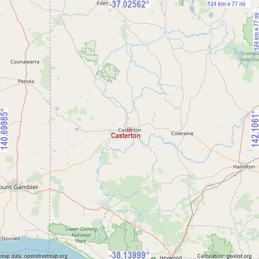
Casterton GPS coordinates[2]
37° 35' 5.604" South, 141° 24' 10.692" East
| Map corner | latitude | longitude |
|---|---|---|
| Upper-left | -37.02562°, | 140.69985° |
| Center: | -37.58489°, | 141.40297° |
| Lower-right: | -38.13999°, | 142.1061° |
| Map W x H: | 123.9×123.9 km | = 77×77mi |
| max Lat: | -10.58257° ⇑83.3% North |
| Casterton: | -37.58489° |
| min Lat: | ⇓16.7% South -43.31423° |
| min Long | Casterton | max Long |
| 113.53327° | 141.40297° | 153.61246° |
| W 24.7%⇐ | ⇒75.3% E |
Elevation
Elevation of Casterton is 49 m = 161 ft, and this is 73 m = 240 ft below average elevation for this country.
| Max E: |
1715 m = 5627 ft | 47.2% |
| Avg. | 122 m = 400 ft | |
| Casterton | 49 m = 161 ft | |
Min E: |
-2 m = -7 ft | 52.8% |
See also: Australia elevation on elevation.city.
Geographical zone
Casterton is located in South temperate zone (between Tropic of Capricorn and the Antarctic Circle). Distance of this Southern Tropic circle is 1573.1 km =977.5 mi to North.| Distance of | km | miles | from Casterton |
|---|---|---|---|
| Equator | 4179 | 2596.7 | to North |
| Tropic Capricorn | 1573.1 | 977.5 | to North |
| Antarctic Circle | 3222.1 | 2002.1 | to South |
| South Pole | 5828 | 3621.4 | to South |


Nearby cities:
15 places around Casterton: (largest is in red/bold)
• Bolwarra
79.9 km =49.6 mi,  166°
166°
• Coleraine
25.4 km =15.8 mi,  93°
93°
• Compton
68.9 km =42.8 mi,  248°
248°
• Edenhope
61.7 km =38.3 mi,  351°
351°
• Glencoe
70.4 km =43.7 mi,  259°
259°
• Hamilton
57.3 km =35.6 mi,  108°
108°
• Heywood
64.1 km =39.8 mi,  161°
161°
• Macarthur
72.5 km =45 mi,  133°
133°
• Moorak
65.8 km =40.9 mi,  241°
241°
• Mount Gambier
61.4 km =38.2 mi, 243°
• Nangwarry
52 km =32.3 mi,  274°
274°
• Penola
55.1 km =34.2 mi,  295°
295°
• Port MacDonnell
80.8 km =50.2 mi,  229°
229°
• Sutton Town
59.5 km =37 mi, 246°
• Worrolong
54.7 km =34 mi, 243°
Sources, notices
• [Note1] Compared only with cities in Australia existing in our database
• [Src1] Map data: © OpenStreetMap contributors (CC-BY-SA)
• [Src2] Other city data from geonames.org with taken over terms of usage.
• [Src3] Geographical zone / Annual Mean Temperature by Robert A. Rohde @ Wikipedia
