Mount Gambier geodata
Mount Gambier (South Australia) is a populated place; located in Australia in Australia/Adelaide (GMT+10.5) time zone. With population of 25,030 people, there are 101 cities with bigger population in this country. Compared to other cities in Australia, 88.6% of cities are located further ↑North; 75.6% of cities are located further →East and 53.1% of cities have higher elevation than Mount Gambier. Note1


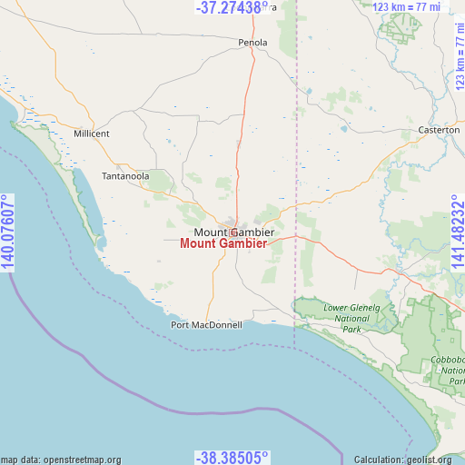
Mount Gambier GPS coordinates[2]
37° 49' 54.48" South, 140° 46' 45.084" East
| Map corner | latitude | longitude |
|---|---|---|
| Upper-left | -37.27438°, | 140.07607° |
| Center: | -37.8318°, | 140.77919° |
| Lower-right: | -38.38505°, | 141.48232° |
| Map W x H: | 123.5×123.5 km | = 76.7×76.7mi |
| max Lat: | -10.58257° ⇑88.6% North |
| Mount Gambier: | -37.8318° |
| min Lat: | ⇓11.4% South -43.31423° |
| min Long | Mount Gambier | max Long |
| 113.53327° | 140.77919° | 153.61246° |
| W 24.4%⇐ | ⇒75.6% E |
Elevation
Elevation of Mount Gambier is 41 m = 135 ft, and this is 81 m = 266 ft below average elevation for this country.
| Max E: |
1715 m = 5627 ft | 53.1% |
| Avg. | 122 m = 400 ft | |
| Mount Gambier | 41 m = 135 ft | |
Min E: |
-2 m = -7 ft | 46.9% |
See also: Australia elevation on elevation.city.
Geographical zone
Mount Gambier is located in South temperate zone (between Tropic of Capricorn and the Antarctic Circle). Distance of this Southern Tropic circle is 1600.6 km =994.6 mi to North.| Distance of | km | miles | from Mount Gambier |
|---|---|---|---|
| Equator | 4206.5 | 2613.8 | to North |
| Tropic Capricorn | 1600.6 | 994.6 | to North |
| Antarctic Circle | 3194.7 | 1985.1 | to South |
| South Pole | 5800.6 | 3604.3 | to South |


Nearby cities:
15 places around Mount Gambier: (largest is in red/bold)
• Beachport
78 km =48.5 mi,  300°
300°
• Bolwarra
88.9 km =55.2 mi,  124°
124°
• Casterton
61.4 km =38.2 mi,  63°
63°
• Coleraine
84.3 km =52.4 mi,  72°
72°
• Compton
9.3 km =5.8 mi,  281°
281°
• Glencoe
20.5 km =12.7 mi,  315°
315°
• Heywood
81.7 km =50.8 mi,  114°
114°
• Millicent
46.1 km =28.6 mi, 304°
• Moorak
4.8 km =3 mi,  222°
222°
• Nangwarry
31.9 km =19.8 mi,  5°
5°
• Penola
51 km =31.7 mi, 5°
• Port MacDonnell
25.6 km =15.9 mi,  195°
195°
• Portland North
87.2 km =54.2 mi,  127°
127°
• Sutton Town
3.6 km =2.2 mi, 5°
• Worrolong
6.7 km =4.2 mi, 64°
Sources, notices
• [Note1] Compared only with cities in Australia existing in our database
• [Src1] Map data: © OpenStreetMap contributors (CC-BY-SA)
• [Src2] Other city data from geonames.org with taken over terms of usage.
• [Src3] Geographical zone / Annual Mean Temperature by Robert A. Rohde @ Wikipedia
