Beachport geodata
Beachport (South Australia) is a populated place; located in Australia in Australia/Adelaide (GMT+10.5) time zone. With population of 583 people, there are 4615 cities with bigger population in this country. Compared to other cities in Australia, 82.5% of cities are located further ↑North; 76.1% of cities are located further →East and 96.8% of cities have higher elevation than Beachport. Note1


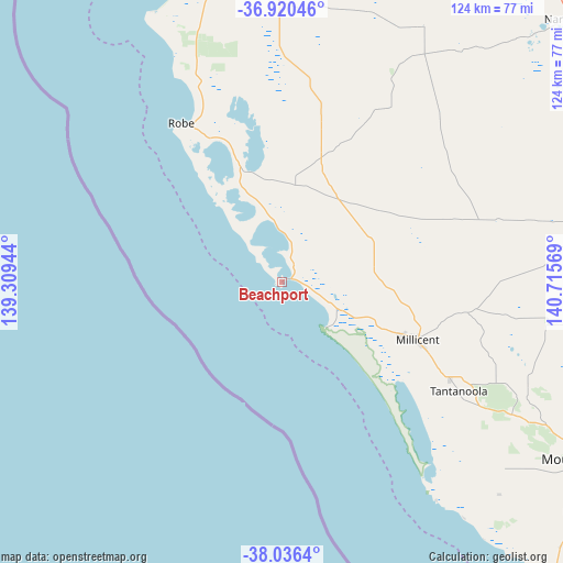
Beachport GPS coordinates[2]
37° 28' 49.836" South, 140° 0' 45.216" East
| Map corner | latitude | longitude |
|---|---|---|
| Upper-left | -36.92046°, | 139.30944° |
| Center: | -37.48051°, | 140.01256° |
| Lower-right: | -38.0364°, | 140.71569° |
| Map W x H: | 124.1×124.1 km | = 77.1×77.1mi |
| max Lat: | -10.58257° ⇑82.5% North |
| Beachport: | -37.48051° |
| min Lat: | ⇓17.5% South -43.31423° |
| min Long | Beachport | max Long |
| 113.53327° | 140.01256° | 153.61246° |
| W 23.9%⇐ | ⇒76.1% E |
Elevation
Elevation of Beachport is 5 m = 16 ft, and this is 117 m = 384 ft below average elevation for this country.
| Max E: |
1715 m = 5627 ft | 96.8% |
| Avg. | 122 m = 400 ft | |
| Beachport | 5 m = 16 ft | |
Min E: |
-2 m = -7 ft | 3.2% |
See also: Australia elevation on elevation.city.
Geographical zone
Beachport is located in South temperate zone (between Tropic of Capricorn and the Antarctic Circle). Distance of this Southern Tropic circle is 1561.5 km =970.3 mi to North.| Distance of | km | miles | from Beachport |
|---|---|---|---|
| Equator | 4167.4 | 2589.5 | to North |
| Tropic Capricorn | 1561.5 | 970.3 | to North |
| Antarctic Circle | 3233.7 | 2009.3 | to South |
| South Pole | 5839.6 | 3628.6 | to South |


Nearby cities:
15 places around Beachport: (largest is in red/bold)
• Casterton
123.1 km =76.5 mi,  95°
95°
• Compton
69.2 km =43 mi,  122°
122°
• Glencoe
58.6 km =36.4 mi,  114°
114°
• Kingston South East
73.6 km =45.7 mi,  348°
348°
• Lucindale
64.7 km =40.2 mi,  29°
29°
• Millicent
32.3 km =20.1 mi, 112°
• Moorak
77.1 km =47.9 mi, 123°
• Mount Gambier
78 km =48.5 mi, 120°
• Nangwarry
71.1 km =44.2 mi, 95°
• Naracoorte
86.6 km =53.8 mi,  47°
47°
• Penola
73.7 km =45.8 mi,  80°
80°
• Port MacDonnell
87.8 km =54.6 mi,  136°
136°
• Robe
41.7 km =25.9 mi,  327°
327°
• Sutton Town
76.6 km =47.6 mi, 117°
• Worrolong
82 km =51 mi, 116°
Sources, notices
• [Note1] Compared only with cities in Australia existing in our database
• [Src1] Map data: © OpenStreetMap contributors (CC-BY-SA)
• [Src2] Other city data from geonames.org with taken over terms of usage.
• [Src3] Geographical zone / Annual Mean Temperature by Robert A. Rohde @ Wikipedia
