Penola geodata
Penola (South Australia) is a populated place; located in Australia in Australia/Adelaide (GMT+10.5) time zone. With population of 1,556 people, there are 3230 cities with bigger population in this country. Compared to other cities in Australia, 82.3% of cities are located further ↑North; 75.5% of cities are located further →East and 59.3% of cities have lower elevation than Penola. Note1


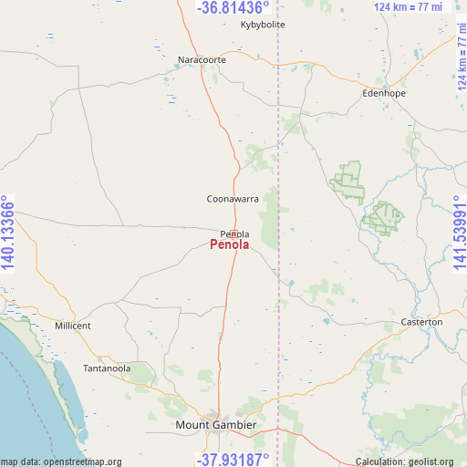
Penola GPS coordinates[2]
37° 22' 30.72" South, 140° 50' 12.408" East
| Map corner | latitude | longitude |
|---|---|---|
| Upper-left | -36.81436°, | 140.13366° |
| Center: | -37.3752°, | 140.83678° |
| Lower-right: | -37.93187°, | 141.53991° |
| Map W x H: | 124.3×124.3 km | = 77.2×77.2mi |
| max Lat: | -10.58257° ⇑82.3% North |
| Penola: | -37.3752° |
| min Lat: | ⇓17.7% South -43.31423° |
| min Long | Penola | max Long |
| 113.53327° | 140.83678° | 153.61246° |
| W 24.5%⇐ | ⇒75.5% E |
Elevation
Elevation of Penola is 62 m = 203 ft, and this is 60 m = 197 ft below average elevation for this country.
| Max E: |
1715 m = 5627 ft | 40.7% |
| Avg. | 122 m = 400 ft | |
| Penola | 62 m = 203 ft | |
Min E: |
-2 m = -7 ft | 59.3% |
See also: Australia elevation on elevation.city.
Geographical zone
Penola is located in South temperate zone (between Tropic of Capricorn and the Antarctic Circle). Distance of this Southern Tropic circle is 1549.8 km =963 mi to North.| Distance of | km | miles | from Penola |
|---|---|---|---|
| Equator | 4155.7 | 2582.2 | to North |
| Tropic Capricorn | 1549.8 | 963 | to North |
| Antarctic Circle | 3245.4 | 2016.6 | to South |
| South Pole | 5851.3 | 3635.8 | to South |


Nearby cities:
15 places around Penola: (largest is in red/bold)
• Beachport
73.7 km =45.8 mi,  260°
260°
• Casterton
55.1 km =34.2 mi,  115°
115°
• Coleraine
79.4 km =49.3 mi,  108°
108°
• Compton
50.9 km =31.6 mi,  196°
196°
• Edenhope
55.5 km =34.5 mi,  47°
47°
• Glencoe
41 km =25.5 mi,  208°
208°
• Lucindale
60.9 km =37.8 mi,  317°
317°
• Millicent
49.4 km =30.7 mi,  240°
240°
• Moorak
55 km =34.2 mi,  188°
188°
• Mount Gambier
51 km =31.7 mi, 185°
• Nangwarry
19.1 km =11.9 mi, 185°
• Naracoorte
47.2 km =29.3 mi,  349°
349°
• Port MacDonnell
76.3 km =47.4 mi, 189°
• Sutton Town
47.5 km =29.5 mi, 185°
• Worrolong
47.9 km =29.8 mi,  178°
178°
Sources, notices
• [Note1] Compared only with cities in Australia existing in our database
• [Src1] Map data: © OpenStreetMap contributors (CC-BY-SA)
• [Src2] Other city data from geonames.org with taken over terms of usage.
• [Src3] Geographical zone / Annual Mean Temperature by Robert A. Rohde @ Wikipedia
