Compton geodata
Compton (South Australia) is a populated place; located in Australia in Australia/Adelaide (GMT+10.5) time zone. With population of 680 people, there are 4361 cities with bigger population in this country. Compared to other cities in Australia, 87.9% of cities are located further ↑North; 75.7% of cities are located further →East and 56.3% of cities have lower elevation than Compton. Note1


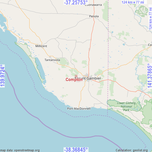
Compton GPS coordinates[2]
37° 48' 54.288" South, 140° 40' 31.872" East
| Map corner | latitude | longitude |
|---|---|---|
| Upper-left | -37.25753°, | 139.9724° |
| Center: | -37.81508°, | 140.67552° |
| Lower-right: | -38.36845°, | 141.37865° |
| Map W x H: | 123.5×123.5 km | = 76.7×76.7mi |
| max Lat: | -10.58257° ⇑87.9% North |
| Compton: | -37.81508° |
| min Lat: | ⇓12.1% South -43.31423° |
| min Long | Compton | max Long |
| 113.53327° | 140.67552° | 153.61246° |
| W 24.3%⇐ | ⇒75.7% E |
Elevation
Elevation of Compton is 56 m = 184 ft, and this is 66 m = 217 ft below average elevation for this country.
| Max E: |
1715 m = 5627 ft | 43.7% |
| Avg. | 122 m = 400 ft | |
| Compton | 56 m = 184 ft | |
Min E: |
-2 m = -7 ft | 56.3% |
See also: Australia elevation on elevation.city.
Geographical zone
Compton is located in South temperate zone (between Tropic of Capricorn and the Antarctic Circle). Distance of this Southern Tropic circle is 1598.7 km =993.4 mi to North.| Distance of | km | miles | from Compton |
|---|---|---|---|
| Equator | 4204.6 | 2612.6 | to North |
| Tropic Capricorn | 1598.7 | 993.4 | to North |
| Antarctic Circle | 3196.5 | 1986.2 | to South |
| South Pole | 5802.4 | 3605.4 | to South |


Nearby cities:
15 places around Compton: (largest is in red/bold)
• Beachport
69.2 km =43 mi,  302°
302°
• Casterton
68.9 km =42.8 mi,  68°
68°
• Coleraine
92.5 km =57.5 mi, 74°
• Glencoe
13.8 km =8.6 mi,  337°
337°
• Heywood
90.8 km =56.4 mi,  112°
112°
• Millicent
37.8 km =23.5 mi,  310°
310°
• Moorak
8 km =5 mi,  132°
132°
• Mount Gambier
9.3 km =5.8 mi,  101°
101°
• Nangwarry
32.3 km =20.1 mi,  22°
22°
• Naracoorte
95.5 km =59.3 mi,  3°
3°
• Penola
50.9 km =31.6 mi, 16°
• Port MacDonnell
26.6 km =16.5 mi,  175°
175°
• Portland North
95.7 km =59.5 mi,  124°
124°
• Sutton Town
9.6 km =6 mi,  79°
79°
• Worrolong
15.2 km =9.4 mi,  86°
86°
Sources, notices
• [Note1] Compared only with cities in Australia existing in our database
• [Src1] Map data: © OpenStreetMap contributors (CC-BY-SA)
• [Src2] Other city data from geonames.org with taken over terms of usage.
• [Src3] Geographical zone / Annual Mean Temperature by Robert A. Rohde @ Wikipedia
