Heywood geodata
Heywood (Victoria) is a populated place; located in Australia in Australia/Melbourne (GMT+11) time zone. With population of 1,665 people, there are 3126 cities with bigger population in this country. Compared to other cities in Australia, 93.1% of cities are located further ↑North; 75.2% of cities are located further →East and 62.8% of cities have higher elevation than Heywood. Note1


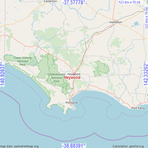
Heywood GPS coordinates[2]
38° 7' 58.584" South, 141° 37' 46.164" East
| Map corner | latitude | longitude |
|---|---|---|
| Upper-left | -37.57778°, | 140.92637° |
| Center: | -38.13294°, | 141.62949° |
| Lower-right: | -38.68391°, | 142.33262° |
| Map W x H: | 123×123 km | = 76.4×76.4mi |
| max Lat: | -10.58257° ⇑93.1% North |
| Heywood: | -38.13294° |
| min Lat: | ⇓6.9% South -43.31423° |
| min Long | Heywood | max Long |
| 113.53327° | 141.62949° | 153.61246° |
| W 24.8%⇐ | ⇒75.2% E |
Elevation
Elevation of Heywood is 29 m = 95 ft, and this is 93 m = 305 ft below average elevation for this country.
| Max E: |
1715 m = 5627 ft | 62.8% |
| Avg. | 122 m = 400 ft | |
| Heywood | 29 m = 95 ft | |
Min E: |
-2 m = -7 ft | 37.2% |
See also: Australia elevation on elevation.city.
Geographical zone
Heywood is located in South temperate zone (between Tropic of Capricorn and the Antarctic Circle). Distance of this Southern Tropic circle is 1634.1 km =1015.4 mi to North.| Distance of | km | miles | from Heywood |
|---|---|---|---|
| Equator | 4240 | 2634.6 | to North |
| Tropic Capricorn | 1634.1 | 1015.4 | to North |
| Antarctic Circle | 3161.2 | 1964.3 | to South |
| South Pole | 5767.1 | 3583.5 | to South |


Nearby cities:
15 places around Heywood: (largest is in red/bold)
• Bolwarra
16.8 km =10.4 mi,  183°
183°
• Bushfield
80.6 km =50.1 mi,  106°
106°
• Casterton
64.1 km =39.8 mi,  341°
341°
• Coleraine
59.7 km =37.1 mi,  5°
5°
• Dennington
74.4 km =46.2 mi, 109°
• Hamilton
55.3 km =34.4 mi,  38°
38°
• Koroit
66.8 km =41.5 mi, 105°
• Macarthur
34.4 km =21.4 mi,  71°
71°
• Penshurst
64.6 km =40.1 mi,  63°
63°
• Port Fairy
60 km =37.3 mi,  117°
117°
• Portland
23.8 km =14.8 mi,  185°
185°
• Portland North
20.2 km =12.6 mi, 194°
• Portland West
25.1 km =15.6 mi, 191°
• Warrnambool
79.9 km =49.6 mi, 110°
• Worrolong
77.5 km =48.2 mi,  297°
297°
Sources, notices
• [Note1] Compared only with cities in Australia existing in our database
• [Src1] Map data: © OpenStreetMap contributors (CC-BY-SA)
• [Src2] Other city data from geonames.org with taken over terms of usage.
• [Src3] Geographical zone / Annual Mean Temperature by Robert A. Rohde @ Wikipedia
