Coleraine geodata
Coleraine (Victoria) is a populated place; located in Australia in Australia/Melbourne (GMT+11) time zone. With population of 993 people, there are 3833 cities with bigger population in this country. Compared to other cities in Australia, 83.4% of cities are located further ↑North; 75.2% of cities are located further →East and 67.3% of cities have lower elevation than Coleraine. Note1


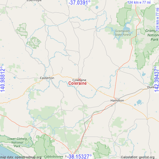
Coleraine GPS coordinates[2]
37° 35' 53.772" South, 141° 41' 28.464" East
| Map corner | latitude | longitude |
|---|---|---|
| Upper-left | -37.0391°, | 140.98812° |
| Center: | -37.59827°, | 141.69124° |
| Lower-right: | -38.15327°, | 142.39437° |
| Map W x H: | 123.9×123.9 km | = 77×77mi |
| max Lat: | -10.58257° ⇑83.4% North |
| Coleraine: | -37.59827° |
| min Lat: | ⇓16.6% South -43.31423° |
| min Long | Coleraine | max Long |
| 113.53327° | 141.69124° | 153.61246° |
| W 24.8%⇐ | ⇒75.2% E |
Elevation
Elevation of Coleraine is 90 m = 295 ft, and this is 32 m = 105 ft below average elevation for this country.
| Max E: |
1715 m = 5627 ft | 32.7% |
| Avg. | 122 m = 400 ft | |
| Coleraine | 90 m = 295 ft | |
Min E: |
-2 m = -7 ft | 67.3% |
See also: Australia elevation on elevation.city.
Geographical zone
Coleraine is located in South temperate zone (between Tropic of Capricorn and the Antarctic Circle). Distance of this Southern Tropic circle is 1574.6 km =978.4 mi to North.| Distance of | km | miles | from Coleraine |
|---|---|---|---|
| Equator | 4180.5 | 2597.6 | to North |
| Tropic Capricorn | 1574.6 | 978.4 | to North |
| Antarctic Circle | 3220.6 | 2001.2 | to South |
| South Pole | 5826.5 | 3620.4 | to South |


Nearby cities:
15 places around Coleraine: (largest is in red/bold)
• Bolwarra
76.5 km =47.5 mi,  184°
184°
• Casterton
25.4 km =15.8 mi,  273°
273°
• Dunkeld
57.8 km =35.9 mi,  95°
95°
• Edenhope
71.5 km =44.4 mi,  330°
330°
• Hamilton
33.3 km =20.7 mi,  119°
119°
• Heywood
59.7 km =37.1 mi,  185°
185°
• Macarthur
55.6 km =34.5 mi,  150°
150°
• Mount Gambier
84.3 km =52.4 mi,  252°
252°
• Nangwarry
77.5 km =48.2 mi, 274°
• Penola
79.4 km =49.3 mi,  288°
288°
• Penshurst
61.1 km =38 mi, 120°
• Portland
83.5 km =51.9 mi, 185°
• Portland North
79.7 km =49.5 mi, 187°
• Sutton Town
83 km =51.6 mi, 254°
• Worrolong
77.7 km =48.3 mi, 252°
Sources, notices
• [Note1] Compared only with cities in Australia existing in our database
• [Src1] Map data: © OpenStreetMap contributors (CC-BY-SA)
• [Src2] Other city data from geonames.org with taken over terms of usage.
• [Src3] Geographical zone / Annual Mean Temperature by Robert A. Rohde @ Wikipedia
