Rylstone geodata
Rylstone (New South Wales) is a populated place; located in Australia in Australia/Sydney (GMT+11) time zone. With population of 906 people, there are 3968 cities with bigger population in this country. Compared to other cities in Australia, 59.8% of cities are located further ↓South; 56.9% of cities are located further ←West and 94.9% of cities have lower elevation than Rylstone. Note1


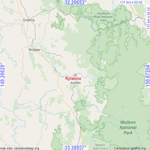
Rylstone GPS coordinates[2]
32° 47' 58.236" South, 149° 58' 9.876" East
| Map corner | latitude | longitude |
|---|---|---|
| Upper-left | -32.20653°, | 149.26629° |
| Center: | -32.79951°, | 149.96941° |
| Lower-right: | -33.38857°, | 150.67254° |
| Map W x H: | 131.4×131.4 km | = 81.6×81.6mi |
| max Lat: | -10.58257° ⇑40.2% North |
| Rylstone: | -32.79951° |
| min Lat: | ⇓59.8% South -43.31423° |
| min Long | Rylstone | max Long |
| 113.53327° | 149.96941° | 153.61246° |
| W 56.9%⇐ | ⇒43.1% E |
Elevation
Elevation of Rylstone is 581 m = 1906 ft, and this is 459 m = 1506 ft above average elevation for this country.
| Max E: |
1715 m = 5627 ft | 5.1% |
| Rylstone | 581 m 1906 ft | |
| Avg. | 122 m = 400 ft | |
Min E: |
-2 m = -7 ft | 94.9% |
See also: Australia elevation on elevation.city.
Geographical zone
Rylstone is located in South temperate zone (between Tropic of Capricorn and the Antarctic Circle). Distance of this Southern Tropic circle is 1041 km =646.8 mi to North.| Distance of | km | miles | from Rylstone |
|---|---|---|---|
| Equator | 3647 | 2266.1 | to North |
| Tropic Capricorn | 1041 | 646.8 | to North |
| Antarctic Circle | 3754.2 | 2332.8 | to South |
| South Pole | 6360.1 | 3952 | to South |


Nearby cities:
15 places around Rylstone: (largest is in red/bold)
• Abercrombie
76.5 km =47.5 mi,  211°
211°
• Bathurst
77.6 km =48.2 mi, 207°
• Bowenfels
77.6 km =48.2 mi,  168°
168°
• Cooks Gap
54.9 km =34.1 mi,  333°
333°
• Eglinton
75.4 km =46.9 mi, 211°
• Gulgong
63.6 km =39.5 mi,  319°
319°
• Kandos
6.5 km =4 mi,  180°
180°
• Kelso
76.8 km =47.7 mi, 206°
• Llanarth
77 km =47.8 mi, 210°
• Marrangaroo
71.8 km =44.6 mi, 168°
• Morts Estate
76.6 km =47.6 mi, 165°
• Mudgee
42.4 km =26.3 mi,  302°
302°
• Portland
62 km =38.5 mi, 178°
• Raglan
74.2 km =46.1 mi,  202°
202°
• Wallerawang
68.6 km =42.6 mi, 172°
Sources, notices
• [Note1] Compared only with cities in Australia existing in our database
• [Src1] Map data: © OpenStreetMap contributors (CC-BY-SA)
• [Src2] Other city data from geonames.org with taken over terms of usage.
• [Src3] Geographical zone / Annual Mean Temperature by Robert A. Rohde @ Wikipedia
