Gulgong geodata
Gulgong (New South Wales) is a populated place; located in Australia in Australia/Sydney (GMT+11) time zone. With population of 2,512 people, there are 2563 cities with bigger population in this country. Compared to other cities in Australia, 62% of cities are located further ↓South; 56.1% of cities are located further ←West and 93% of cities have lower elevation than Gulgong. Note1


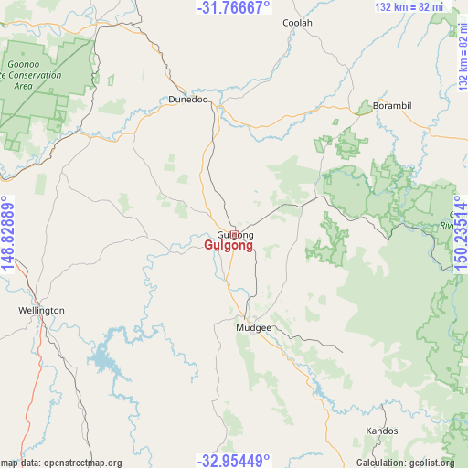
Gulgong GPS coordinates[2]
32° 21' 45.108" South, 149° 31' 55.236" East
| Map corner | latitude | longitude |
|---|---|---|
| Upper-left | -31.76667°, | 148.82889° |
| Center: | -32.36253°, | 149.53201° |
| Lower-right: | -32.95449°, | 150.23514° |
| Map W x H: | 132.1×132.1 km | = 82.1×82.1mi |
| max Lat: | -10.58257° ⇑38% North |
| Gulgong: | -32.36253° |
| min Lat: | ⇓62% South -43.31423° |
| min Long | Gulgong | max Long |
| 113.53327° | 149.53201° | 153.61246° |
| W 56.1%⇐ | ⇒43.9% E |
Elevation
Elevation of Gulgong is 471 m = 1545 ft, and this is 349 m = 1145 ft above average elevation for this country.
| Max E: |
1715 m = 5627 ft | 7% |
| Gulgong | 471 m 1545 ft | |
| Avg. | 122 m = 400 ft | |
Min E: |
-2 m = -7 ft | 93% |
See also: Australia elevation on elevation.city.
Geographical zone
Gulgong is located in South temperate zone (between Tropic of Capricorn and the Antarctic Circle). Distance of this Southern Tropic circle is 992.5 km =616.7 mi to North.| Distance of | km | miles | from Gulgong |
|---|---|---|---|
| Equator | 3598.4 | 2235.9 | to North |
| Tropic Capricorn | 992.5 | 616.7 | to North |
| Antarctic Circle | 3802.8 | 2362.9 | to South |
| South Pole | 6408.7 | 3982.2 | to South |


Nearby cities:
15 places around Gulgong: (largest is in red/bold)
• Cooks Gap
16.9 km =10.5 mi,  87°
87°
• Coolah
61.9 km =38.5 mi,  16°
16°
• Dubbo
88.1 km =54.7 mi,  278°
278°
• Dunedoo
40.8 km =25.4 mi,  340°
340°
• Eulomogo
80.5 km =50 mi, 277°
• Geurie
66 km =41 mi,  266°
266°
• Kandos
68.6 km =42.6 mi,  143°
143°
• Mendooran
71.3 km =44.3 mi,  327°
327°
• Merriwa
81.3 km =50.5 mi,  72°
72°
• Montefiores
59.3 km =36.8 mi,  251°
251°
• Mudgee
26.3 km =16.3 mi,  168°
168°
• Rylstone
63.6 km =39.5 mi, 139°
• Wellington
59.1 km =36.7 mi, 248°
• Wongarbon
72.7 km =45.2 mi, 272°
• Wuuluman
47 km =29.2 mi,  243°
243°
Sources, notices
• [Note1] Compared only with cities in Australia existing in our database
• [Src1] Map data: © OpenStreetMap contributors (CC-BY-SA)
• [Src2] Other city data from geonames.org with taken over terms of usage.
• [Src3] Geographical zone / Annual Mean Temperature by Robert A. Rohde @ Wikipedia
