Kandos geodata
Kandos (New South Wales) is a populated place; located in Australia in Australia/Sydney (GMT+11) time zone. With population of 1,301 people, there are 3476 cities with bigger population in this country. Compared to other cities in Australia, 59.3% of cities are located further ↓South; 56.9% of cities are located further ←West and 96.9% of cities have lower elevation than Kandos. Note1


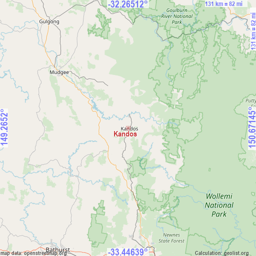
Kandos GPS coordinates[2]
32° 51' 27.792" South, 149° 58' 5.952" East
| Map corner | latitude | longitude |
|---|---|---|
| Upper-left | -32.26512°, | 149.2652° |
| Center: | -32.85772°, | 149.96832° |
| Lower-right: | -33.44639°, | 150.67145° |
| Map W x H: | 131.3×131.3 km | = 81.6×81.6mi |
| max Lat: | -10.58257° ⇑40.7% North |
| Kandos: | -32.85772° |
| min Lat: | ⇓59.3% South -43.31423° |
| min Long | Kandos | max Long |
| 113.53327° | 149.96832° | 153.61246° |
| W 56.9%⇐ | ⇒43.1% E |
Elevation
Elevation of Kandos is 628 m = 2060 ft, and this is 506 m = 1660 ft above average elevation for this country.
| Max E: |
1715 m = 5627 ft | 3.1% |
| Kandos | 628 m 2060 ft | |
| Avg. | 122 m = 400 ft | |
Min E: |
-2 m = -7 ft | 96.9% |
See also: Australia elevation on elevation.city.
Geographical zone
Kandos is located in South temperate zone (between Tropic of Capricorn and the Antarctic Circle). Distance of this Southern Tropic circle is 1047.5 km =650.9 mi to North.| Distance of | km | miles | from Kandos |
|---|---|---|---|
| Equator | 3653.4 | 2270.1 | to North |
| Tropic Capricorn | 1047.5 | 650.9 | to North |
| Antarctic Circle | 3747.7 | 2328.7 | to South |
| South Pole | 6353.6 | 3947.9 | to South |


Nearby cities:
15 places around Kandos: (largest is in red/bold)
• Abercrombie
70.9 km =44.1 mi,  213°
213°
• Bowenfels
71.3 km =44.3 mi,  167°
167°
• Cooks Gap
60.8 km =37.8 mi,  336°
336°
• Eglinton
69.9 km =43.4 mi, 214°
• Gulgong
68.6 km =42.6 mi,  323°
323°
• Kelso
71 km =44.1 mi, 208°
• Lithgow
71.7 km =44.6 mi, 166°
• Llanarth
71.4 km =44.4 mi, 212°
• Marrangaroo
65.5 km =40.7 mi, 167°
• Morts Estate
70.4 km =43.7 mi,  164°
164°
• Mudgee
46.1 km =28.6 mi,  309°
309°
• Portland
55.5 km =34.5 mi,  178°
178°
• Raglan
68.2 km =42.4 mi,  204°
204°
• Rylstone
6.5 km =4 mi,  0°
0°
• Wallerawang
62.2 km =38.6 mi, 171°
Sources, notices
• [Note1] Compared only with cities in Australia existing in our database
• [Src1] Map data: © OpenStreetMap contributors (CC-BY-SA)
• [Src2] Other city data from geonames.org with taken over terms of usage.
• [Src3] Geographical zone / Annual Mean Temperature by Robert A. Rohde @ Wikipedia
