Mudgee geodata
Mudgee (New South Wales) is a populated place; located in Australia in Australia/Sydney (GMT+11) time zone. With population of 11,035 people, there are 494 cities with bigger population in this country. Compared to other cities in Australia, 61% of cities are located further ↓South; 56.4% of cities are located further ←West and 92.6% of cities have lower elevation than Mudgee. Note1


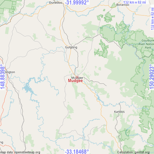
Mudgee GPS coordinates[2]
32° 35' 39.336" South, 149° 35' 13.56" East
| Map corner | latitude | longitude |
|---|---|---|
| Upper-left | -31.99992°, | 148.88398° |
| Center: | -32.59426°, | 149.5871° |
| Lower-right: | -33.18468°, | 150.29023° |
| Map W x H: | 131.7×131.7 km | = 81.8×81.8mi |
| max Lat: | -10.58257° ⇑39% North |
| Mudgee: | -32.59426° |
| min Lat: | ⇓61% South -43.31423° |
| min Long | Mudgee | max Long |
| 113.53327° | 149.5871° | 153.61246° |
| W 56.4%⇐ | ⇒43.6% E |
Elevation
Elevation of Mudgee is 459 m = 1506 ft, and this is 337 m = 1106 ft above average elevation for this country.
| Max E: |
1715 m = 5627 ft | 7.4% |
| Mudgee | 459 m 1506 ft | |
| Avg. | 122 m = 400 ft | |
Min E: |
-2 m = -7 ft | 92.6% |
See also: Australia elevation on elevation.city.
Geographical zone
Mudgee is located in South temperate zone (between Tropic of Capricorn and the Antarctic Circle). Distance of this Southern Tropic circle is 1018.2 km =632.7 mi to North.| Distance of | km | miles | from Mudgee |
|---|---|---|---|
| Equator | 3624.1 | 2251.9 | to North |
| Tropic Capricorn | 1018.2 | 632.7 | to North |
| Antarctic Circle | 3777 | 2346.9 | to South |
| South Pole | 6382.9 | 3966.1 | to South |


Nearby cities:
15 places around Mudgee: (largest is in red/bold)
• Clifton Grove
83.7 km =52 mi,  208°
208°
• Cooks Gap
29 km =18 mi,  23°
23°
• Coolah
86.1 km =53.5 mi,  8°
8°
• Dunedoo
67 km =41.6 mi,  343°
343°
• Eglinton
87.1 km =54.1 mi,  182°
182°
• Geurie
74.2 km =46.1 mi,  286°
286°
• Gulgong
26.3 km =16.3 mi,  348°
348°
• Kandos
46.1 km =28.6 mi,  129°
129°
• Molong
86.9 km =54 mi,  230°
230°
• Montefiores
61.6 km =38.3 mi,  276°
276°
• Mullion Creek
73 km =45.4 mi,  216°
216°
• Rylstone
42.4 km =26.3 mi,  122°
122°
• Wellington
60.3 km =37.5 mi,  274°
274°
• Wongarbon
82.9 km =51.5 mi, 290°
• Wuuluman
47.5 km =29.5 mi, 275°
Sources, notices
• [Note1] Compared only with cities in Australia existing in our database
• [Src1] Map data: © OpenStreetMap contributors (CC-BY-SA)
• [Src2] Other city data from geonames.org with taken over terms of usage.
• [Src3] Geographical zone / Annual Mean Temperature by Robert A. Rohde @ Wikipedia
