Wuuluman geodata
Wuuluman (New South Wales) is a populated place; located in Australia in Australia/Sydney (GMT+11) time zone. With population of 770 people, there are 4204 cities with bigger population in this country. Compared to other cities in Australia, 61.3% of cities are located further ↓South; 53.6% of cities are located further ←West and 91% of cities have lower elevation than Wuuluman. Note1


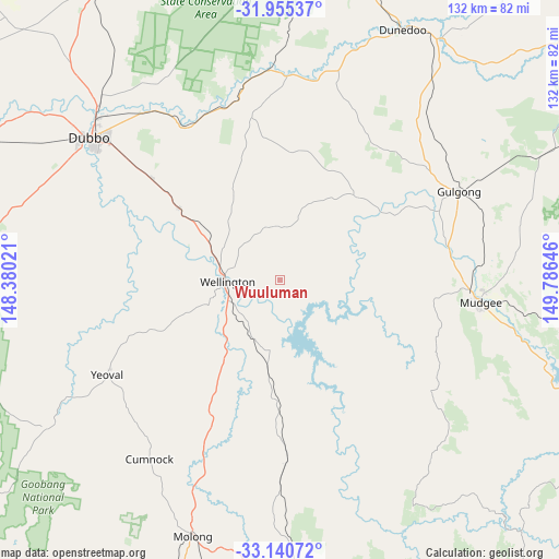
Wuuluman GPS coordinates[2]
32° 33' 0" South, 149° 4' 59.988" East
| Map corner | latitude | longitude |
|---|---|---|
| Upper-left | -31.95537°, | 148.38021° |
| Center: | -32.55°, | 149.08333° |
| Lower-right: | -33.14072°, | 149.78646° |
| Map W x H: | 131.8×131.8 km | = 81.9×81.9mi |
| max Lat: | -10.58257° ⇑38.7% North |
| Wuuluman: | -32.55° |
| min Lat: | ⇓61.3% South -43.31423° |
| min Long | Wuuluman | max Long |
| 113.53327° | 149.08333° | 153.61246° |
| W 53.6%⇐ | ⇒46.4% E |
Elevation
Elevation of Wuuluman is 411 m = 1348 ft, and this is 289 m = 948 ft above average elevation for this country.
| Max E: |
1715 m = 5627 ft | 9% |
| Wuuluman | 411 m 1348 ft | |
| Avg. | 122 m = 400 ft | |
Min E: |
-2 m = -7 ft | 91% |
See also: Australia elevation on elevation.city.
Geographical zone
Wuuluman is located in South temperate zone (between Tropic of Capricorn and the Antarctic Circle). Distance of this Southern Tropic circle is 1013.3 km =629.6 mi to North.| Distance of | km | miles | from Wuuluman |
|---|---|---|---|
| Equator | 3619.2 | 2248.9 | to North |
| Tropic Capricorn | 1013.3 | 629.6 | to North |
| Antarctic Circle | 3782 | 2350 | to South |
| South Pole | 6387.8 | 3969.2 | to South |


Nearby cities:
15 places around Wuuluman: (largest is in red/bold)
• Clifton Grove
78.6 km =48.8 mi,  175°
175°
• Cooks Gap
62.8 km =39 mi,  69°
69°
• Dubbo
56.4 km =35 mi,  307°
307°
• Dunedoo
65.9 km =40.9 mi,  25°
25°
• Eulomogo
49 km =30.4 mi, 309°
• Geurie
29 km =18 mi,  304°
304°
• Gulgong
47 km =29.2 mi,  63°
63°
• Manildra
79.4 km =49.3 mi,  207°
207°
• Mendooran
80.9 km =50.3 mi,  2°
2°
• Molong
63.5 km =39.5 mi,  198°
198°
• Montefiores
14.2 km =8.8 mi,  277°
277°
• Mudgee
47.5 km =29.5 mi,  95°
95°
• Mullion Creek
64.1 km =39.8 mi, 176°
• Wellington
13 km =8.1 mi,  267°
267°
• Wongarbon
38.8 km =24.1 mi, 308°
Sources, notices
• [Note1] Compared only with cities in Australia existing in our database
• [Src1] Map data: © OpenStreetMap contributors (CC-BY-SA)
• [Src2] Other city data from geonames.org with taken over terms of usage.
• [Src3] Geographical zone / Annual Mean Temperature by Robert A. Rohde @ Wikipedia
