Mendooran geodata
Mendooran (New South Wales) is a populated place; located in Australia in Australia/Sydney (GMT+11) time zone. With population of 549 people, there are 4707 cities with bigger population in this country. Compared to other cities in Australia, 68% of cities are located further ↓South; 54.4% of cities are located further ←West and 89.1% of cities have lower elevation than Mendooran. Note1


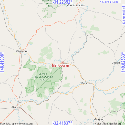
Mendooran GPS coordinates[2]
31° 49' 22.368" South, 149° 7' 19.92" East
| Map corner | latitude | longitude |
|---|---|---|
| Upper-left | -31.22352°, | 148.41908° |
| Center: | -31.82288°, | 149.1222° |
| Lower-right: | -32.41837°, | 149.82533° |
| Map W x H: | 132.9×132.9 km | = 82.6×82.6mi |
| max Lat: | -10.58257° ⇑32% North |
| Mendooran: | -31.82288° |
| min Lat: | ⇓68% South -43.31423° |
| min Long | Mendooran | max Long |
| 113.53327° | 149.1222° | 153.61246° |
| W 54.4%⇐ | ⇒45.6% E |
Elevation
Elevation of Mendooran is 351 m = 1152 ft, and this is 229 m = 751 ft above average elevation for this country.
| Max E: |
1715 m = 5627 ft | 10.9% |
| Mendooran | 351 m 1152 ft | |
| Avg. | 122 m = 400 ft | |
Min E: |
-2 m = -7 ft | 89.1% |
See also: Australia elevation on elevation.city.
Geographical zone
Mendooran is located in South temperate zone (between Tropic of Capricorn and the Antarctic Circle). Distance of this Southern Tropic circle is 932.5 km =579.4 mi to North.| Distance of | km | miles | from Mendooran |
|---|---|---|---|
| Equator | 3538.4 | 2198.7 | to North |
| Tropic Capricorn | 932.5 | 579.4 | to North |
| Antarctic Circle | 3862.8 | 2400.2 | to South |
| South Pole | 6468.7 | 4019.5 | to South |


Nearby cities:
15 places around Mendooran: (largest is in red/bold)
• Binnaway
38.7 km =24 mi,  38°
38°
• Cooks Gap
81.2 km =50.5 mi,  136°
136°
• Coolah
56.1 km =34.9 mi,  90°
90°
• Coonabarabran
62.5 km =38.8 mi,  13°
13°
• Dubbo
67.5 km =41.9 mi,  226°
226°
• Dunedoo
33 km =20.5 mi,  130°
130°
• Eulomogo
64.4 km =40 mi,  219°
219°
• Geurie
69.9 km =43.4 mi,  203°
203°
• Gilgandra
45.2 km =28.1 mi,  285°
285°
• Gulargambone
82 km =51 mi,  311°
311°
• Gulgong
71.3 km =44.3 mi,  147°
147°
• Montefiores
81 km =50.3 mi,  192°
192°
• Wellington
83.2 km =51.7 mi, 191°
• Wongarbon
66.2 km =41.1 mi,  211°
211°
• Wuuluman
80.9 km =50.3 mi,  182°
182°
Sources, notices
• [Note1] Compared only with cities in Australia existing in our database
• [Src1] Map data: © OpenStreetMap contributors (CC-BY-SA)
• [Src2] Other city data from geonames.org with taken over terms of usage.
• [Src3] Geographical zone / Annual Mean Temperature by Robert A. Rohde @ Wikipedia
