Gilgandra geodata
Gilgandra (New South Wales) is a populated place; located in Australia in Australia/Sydney (GMT+11) time zone. With population of 3,095 people, there are 2190 cities with bigger population in this country. Compared to other cities in Australia, 68.8% of cities are located further ↓South; 52% of cities are located further ←West and 87% of cities have lower elevation than Gilgandra. Note1


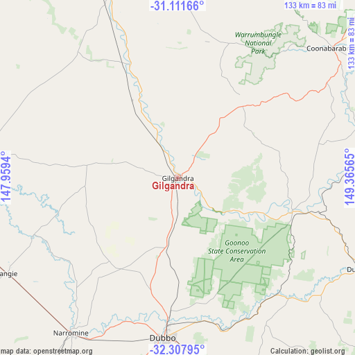
Gilgandra GPS coordinates[2]
31° 42' 42.228" South, 148° 39' 45.072" East
| Map corner | latitude | longitude |
|---|---|---|
| Upper-left | -31.11166°, | 147.9594° |
| Center: | -31.71173°, | 148.66252° |
| Lower-right: | -32.30795°, | 149.36565° |
| Map W x H: | 133×133 km | = 82.6×82.6mi |
| max Lat: | -10.58257° ⇑31.2% North |
| Gilgandra: | -31.71173° |
| min Lat: | ⇓68.8% South -43.31423° |
| min Long | Gilgandra | max Long |
| 113.53327° | 148.66252° | 153.61246° |
| W 52%⇐ | ⇒48% E |
Elevation
Elevation of Gilgandra is 287 m = 942 ft, and this is 165 m = 541 ft above average elevation for this country.
| Max E: |
1715 m = 5627 ft | 13% |
| Gilgandra | 287 m 942 ft | |
| Avg. | 122 m = 400 ft | |
Min E: |
-2 m = -7 ft | 87% |
See also: Australia elevation on elevation.city.
Geographical zone
Gilgandra is located in South temperate zone (between Tropic of Capricorn and the Antarctic Circle). Distance of this Southern Tropic circle is 920.1 km =571.7 mi to North.| Distance of | km | miles | from Gilgandra |
|---|---|---|---|
| Equator | 3526 | 2191 | to North |
| Tropic Capricorn | 920.1 | 571.7 | to North |
| Antarctic Circle | 3875.2 | 2407.9 | to South |
| South Pole | 6481 | 4027.1 | to South |


Nearby cities:
15 places around Gilgandra: (largest is in red/bold)
• Baradine
93.2 km =57.9 mi,  24°
24°
• Binnaway
70.1 km =43.6 mi,  75°
75°
• Coonabarabran
75.8 km =47.1 mi,  50°
50°
• Coonamble
88.2 km =54.8 mi,  342°
342°
• Dubbo
59.3 km =36.8 mi,  185°
185°
• Dunedoo
76.3 km =47.4 mi,  116°
116°
• Eulomogo
61.7 km =38.3 mi,  178°
178°
• Geurie
78.2 km =48.6 mi,  168°
168°
• Gulargambone
45.6 km =28.3 mi, 336°
• Mendooran
45.2 km =28.1 mi,  105°
105°
• Montefiores
94.8 km =58.9 mi,  164°
164°
• Narromine
70.1 km =43.6 mi,  214°
214°
• Trangie
73.3 km =45.5 mi,  240°
240°
• Warren
78.4 km =48.7 mi,  270°
270°
• Wongarbon
69.7 km =43.3 mi, 172°
Sources, notices
• [Note1] Compared only with cities in Australia existing in our database
• [Src1] Map data: © OpenStreetMap contributors (CC-BY-SA)
• [Src2] Other city data from geonames.org with taken over terms of usage.
• [Src3] Geographical zone / Annual Mean Temperature by Robert A. Rohde @ Wikipedia
