Kingaroy geodata
Kingaroy (Queensland) is a populated place; located in Australia in Australia/Brisbane (GMT+10) time zone. With population of 10,064 people, there are 595 cities with bigger population in this country. Compared to other cities in Australia, 87.5% of cities are located further ↓South; 81.5% of cities are located further ←West and 91.7% of cities have lower elevation than Kingaroy. Note1


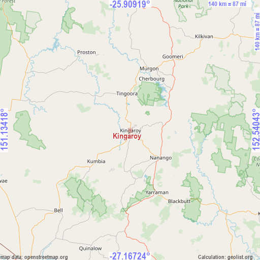
Kingaroy GPS coordinates[2]
26° 32' 23.784" South, 151° 50' 14.28" East
| Map corner | latitude | longitude |
|---|---|---|
| Upper-left | -25.90919°, | 151.13418° |
| Center: | -26.53994°, | 151.8373° |
| Lower-right: | -27.16724°, | 152.54043° |
| Map W x H: | 139.9×139.9 km | = 86.9×86.9mi |
| max Lat: | -10.58257° ⇑12.5% North |
| Kingaroy: | -26.53994° |
| min Lat: | ⇓87.5% South -43.31423° |
| min Long | Kingaroy | max Long |
| 113.53327° | 151.8373° | 153.61246° |
| W 81.5%⇐ | ⇒18.5% E |
Elevation
Elevation of Kingaroy is 433 m = 1421 ft, and this is 311 m = 1020 ft above average elevation for this country.
| Max E: |
1715 m = 5627 ft | 8.3% |
| Kingaroy | 433 m 1421 ft | |
| Avg. | 122 m = 400 ft | |
Min E: |
-2 m = -7 ft | 91.7% |
See also: Australia elevation on elevation.city.
Geographical zone
Kingaroy is located in South temperate zone (between Tropic of Capricorn and the Antarctic Circle). Distance of this Southern Tropic circle is 345 km =214.4 mi to North.| Distance of | km | miles | from Kingaroy |
|---|---|---|---|
| Equator | 2951 | 1833.7 | to North |
| Tropic Capricorn | 345 | 214.4 | to North |
| Antarctic Circle | 4450.2 | 2765.2 | to South |
| South Pole | 7056.1 | 4384.5 | to South |


Nearby cities:
15 places around Kingaroy: (largest is in red/bold)
• Blackbutt
46.6 km =29 mi,  145°
145°
• Booie
10.4 km =6.5 mi,  88°
88°
• Cherbourg
29.9 km =18.6 mi,  22°
22°
• Goomeri
45.8 km =28.5 mi,  30°
30°
• Jandowae
77 km =47.8 mi,  249°
249°
• Kilkivan
64 km =39.8 mi,  38°
38°
• Murgon
34.7 km =21.6 mi, 17°
• Nanango
22 km =13.7 mi,  131°
131°
• South Nanango
26.7 km =16.6 mi, 151°
• Taabinga
4.8 km =3 mi,  184°
184°
• Toogoolawah
81 km =50.3 mi,  138°
138°
• Wattle Camp
15.5 km =9.6 mi,  53°
53°
• Widgee
69.2 km =43 mi,  58°
58°
• Wondai
25 km =15.5 mi,  8°
8°
• Yarraman
36.5 km =22.7 mi,  156°
156°
Sources, notices
• [Note1] Compared only with cities in Australia existing in our database
• [Src1] Map data: © OpenStreetMap contributors (CC-BY-SA)
• [Src2] Other city data from geonames.org with taken over terms of usage.
• [Src3] Geographical zone / Annual Mean Temperature by Robert A. Rohde @ Wikipedia
