Wattle Camp geodata
Wattle Camp (Queensland) is a section of populated place; located in Australia in Australia/Brisbane (GMT+10) time zone. With population of 514 people, there are 4837 cities with bigger population in this country. Compared to other cities in Australia, 87.7% of cities are located further ↓South; 82.4% of cities are located further ←West and 90% of cities have lower elevation than Wattle Camp. Note1


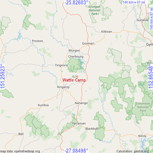
Wattle Camp GPS coordinates[2]
26° 27' 26.028" South, 151° 57' 44.46" East
| Map corner | latitude | longitude |
|---|---|---|
| Upper-left | -25.82603°, | 151.25923° |
| Center: | -26.45723°, | 151.96235° |
| Lower-right: | -27.08498°, | 152.66548° |
| Map W x H: | 140×140 km | = 87×87mi |
| max Lat: | -10.58257° ⇑12.3% North |
| Wattle Camp: | -26.45723° |
| min Lat: | ⇓87.7% South -43.31423° |
| min Long | Wattle Camp | max Long |
| 113.53327° | 151.96235° | 153.61246° |
| W 82.4%⇐ | ⇒17.6% E |
Elevation
Elevation of Wattle Camp is 370 m = 1214 ft, and this is 248 m = 814 ft above average elevation for this country.
| Max E: |
1715 m = 5627 ft | 10% |
| Wattle Camp | 370 m 1214 ft | |
| Avg. | 122 m = 400 ft | |
Min E: |
-2 m = -7 ft | 90% |
See also: Australia elevation on elevation.city.
Geographical zone
Wattle Camp is located in South temperate zone (between Tropic of Capricorn and the Antarctic Circle). Distance of this Southern Tropic circle is 335.8 km =208.7 mi to North.| Distance of | km | miles | from Wattle Camp |
|---|---|---|---|
| Equator | 2941.8 | 1827.9 | to North |
| Tropic Capricorn | 335.8 | 208.7 | to North |
| Antarctic Circle | 4459.4 | 2770.9 | to South |
| South Pole | 7065.3 | 4390.2 | to South |


Nearby cities:
15 places around Wattle Camp: (largest is in red/bold)
• Blackbutt
49.7 km =30.9 mi,  163°
163°
• Booie
9.1 km =5.7 mi,  193°
193°
• Cherbourg
18.4 km =11.4 mi,  356°
356°
• Goomeri
32.2 km =20 mi,  19°
19°
• Kilkivan
49.3 km =30.6 mi,  33°
33°
• Kingaroy
15.5 km =9.6 mi,  233°
233°
• Murgon
24.1 km =15 mi,  354°
354°
• Nanango
24.2 km =15 mi,  170°
170°
• Pie Creek
69.1 km =42.9 mi,  68°
68°
• South Nanango
32.6 km =20.3 mi,  179°
179°
• Taabinga
19 km =11.8 mi,  222°
222°
• The Palms
68.2 km =42.4 mi, 65°
• Widgee
53.8 km =33.4 mi,  60°
60°
• Wondai
17.9 km =11.1 mi,  329°
329°
• Yarraman
42.8 km =26.6 mi, 177°
Sources, notices
• [Note1] Compared only with cities in Australia existing in our database
• [Src1] Map data: © OpenStreetMap contributors (CC-BY-SA)
• [Src2] Other city data from geonames.org with taken over terms of usage.
• [Src3] Geographical zone / Annual Mean Temperature by Robert A. Rohde @ Wikipedia
