Yarraman geodata
Yarraman (Queensland) is a populated place; located in Australia in Australia/Brisbane (GMT+10) time zone. With population of 1,045 people, there are 3760 cities with bigger population in this country. Compared to other cities in Australia, 85.8% of cities are located further ↓South; 82.6% of cities are located further ←West and 92.1% of cities have lower elevation than Yarraman. Note1


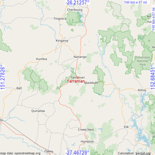
Yarraman GPS coordinates[2]
26° 50' 30.012" South, 151° 58' 52.968" East
| Map corner | latitude | longitude |
|---|---|---|
| Upper-left | -26.21257°, | 151.27826° |
| Center: | -26.84167°, | 151.98138° |
| Lower-right: | -27.46729°, | 152.68451° |
| Map W x H: | 139.5×139.5 km | = 86.7×86.7mi |
| max Lat: | -10.58257° ⇑14.2% North |
| Yarraman: | -26.84167° |
| min Lat: | ⇓85.8% South -43.31423° |
| min Long | Yarraman | max Long |
| 113.53327° | 151.98138° | 153.61246° |
| W 82.6%⇐ | ⇒17.4% E |
Elevation
Elevation of Yarraman is 443 m = 1453 ft, and this is 321 m = 1053 ft above average elevation for this country.
| Max E: |
1715 m = 5627 ft | 7.9% |
| Yarraman | 443 m 1453 ft | |
| Avg. | 122 m = 400 ft | |
Min E: |
-2 m = -7 ft | 92.1% |
See also: Australia elevation on elevation.city.
Geographical zone
Yarraman is located in South temperate zone (between Tropic of Capricorn and the Antarctic Circle). Distance of this Southern Tropic circle is 378.6 km =235.3 mi to North.| Distance of | km | miles | from Yarraman |
|---|---|---|---|
| Equator | 2984.5 | 1854.5 | to North |
| Tropic Capricorn | 378.6 | 235.3 | to North |
| Antarctic Circle | 4416.7 | 2744.4 | to South |
| South Pole | 7022.5 | 4363.6 | to South |


Nearby cities:
15 places around Yarraman: (largest is in red/bold)
• Blackbutt
12.9 km =8 mi,  112°
112°
• Booie
34.1 km =21.2 mi,  353°
353°
• Cherbourg
61.2 km =38 mi,  357°
357°
• Crows Nest
47 km =29.2 mi,  171°
171°
• Esk
62.1 km =38.6 mi,  135°
135°
• Goombungee
53.4 km =33.2 mi,  193°
193°
• Kilcoy
59 km =36.7 mi,  101°
101°
• Kingaroy
36.5 km =22.7 mi,  336°
336°
• Meringandan West
64.5 km =40.1 mi, 188°
• Nanango
19 km =11.8 mi,  6°
6°
• South Nanango
10.3 km =6.4 mi, 351°
• Taabinga
32.3 km =20.1 mi,  332°
332°
• Toogoolawah
47.7 km =29.6 mi,  124°
124°
• Wattle Camp
42.8 km =26.6 mi, 357°
• Wondai
59.3 km =36.8 mi, 349°
Sources, notices
• [Note1] Compared only with cities in Australia existing in our database
• [Src1] Map data: © OpenStreetMap contributors (CC-BY-SA)
• [Src2] Other city data from geonames.org with taken over terms of usage.
• [Src3] Geographical zone / Annual Mean Temperature by Robert A. Rohde @ Wikipedia
