Nanango geodata
Nanango (Queensland) is a populated place; located in Australia in Australia/Brisbane (GMT+10) time zone. With population of 3,573 people, there are 1968 cities with bigger population in this country. Compared to other cities in Australia, 86.8% of cities are located further ↓South; 82.7% of cities are located further ←West and 89.1% of cities have lower elevation than Nanango. Note1


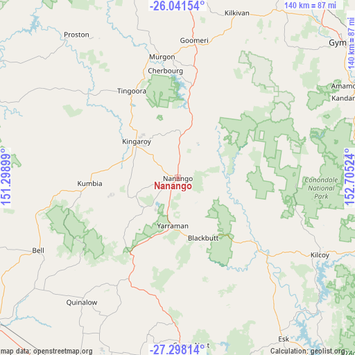
Nanango GPS coordinates[2]
26° 40' 17.652" South, 152° 0' 7.596" East
| Map corner | latitude | longitude |
|---|---|---|
| Upper-left | -26.04154°, | 151.29899° |
| Center: | -26.67157°, | 152.00211° |
| Lower-right: | -27.29814°, | 152.70524° |
| Map W x H: | 139.7×139.7 km | = 86.8×86.8mi |
| max Lat: | -10.58257° ⇑13.2% North |
| Nanango: | -26.67157° |
| min Lat: | ⇓86.8% South -43.31423° |
| min Long | Nanango | max Long |
| 113.53327° | 152.00211° | 153.61246° |
| W 82.7%⇐ | ⇒17.3% E |
Elevation
Elevation of Nanango is 349 m = 1145 ft, and this is 227 m = 745 ft above average elevation for this country.
| Max E: |
1715 m = 5627 ft | 10.9% |
| Nanango | 349 m 1145 ft | |
| Avg. | 122 m = 400 ft | |
Min E: |
-2 m = -7 ft | 89.1% |
See also: Australia elevation on elevation.city.
Geographical zone
Nanango is located in South temperate zone (between Tropic of Capricorn and the Antarctic Circle). Distance of this Southern Tropic circle is 359.7 km =223.5 mi to North.| Distance of | km | miles | from Nanango |
|---|---|---|---|
| Equator | 2965.6 | 1842.7 | to North |
| Tropic Capricorn | 359.7 | 223.5 | to North |
| Antarctic Circle | 4435.6 | 2756.2 | to South |
| South Pole | 7041.5 | 4375.4 | to South |


Nearby cities:
15 places around Nanango: (largest is in red/bold)
• Blackbutt
25.8 km =16 mi,  157°
157°
• Booie
16.1 km =10 mi,  338°
338°
• Cherbourg
42.5 km =26.4 mi,  353°
353°
• Crows Nest
65.6 km =40.8 mi,  175°
175°
• Goomeri
54.6 km =33.9 mi,  6°
6°
• Kilcoy
63.5 km =39.5 mi,  118°
118°
• Kingaroy
22 km =13.7 mi,  311°
311°
• Murgon
48.2 km =30 mi, 352°
• South Nanango
9.4 km =5.8 mi,  201°
201°
• Taabinga
19.4 km =12.1 mi,  300°
300°
• Toogoolawah
59.2 km =36.8 mi,  141°
141°
• Wattle Camp
24.2 km =15 mi, 350°
• Widgee
66.1 km =41.1 mi,  40°
40°
• Wondai
41.4 km =25.7 mi, 341°
• Yarraman
19 km =11.8 mi,  186°
186°
Sources, notices
• [Note1] Compared only with cities in Australia existing in our database
• [Src1] Map data: © OpenStreetMap contributors (CC-BY-SA)
• [Src2] Other city data from geonames.org with taken over terms of usage.
• [Src3] Geographical zone / Annual Mean Temperature by Robert A. Rohde @ Wikipedia
