Willaura geodata
Willaura (Victoria) is a populated place; located in Australia in Australia/Melbourne (GMT+11) time zone. With population of 524 people, there are 4801 cities with bigger population in this country. Compared to other cities in Australia, 82.8% of cities are located further ↑North; 74.2% of cities are located further →East and 85.2% of cities have lower elevation than Willaura. Note1


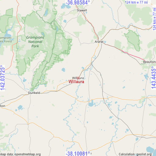
Willaura GPS coordinates[2]
37° 32' 43.476" South, 142° 44' 25.332" East
| Map corner | latitude | longitude |
|---|---|---|
| Upper-left | -36.98584°, | 142.03725° |
| Center: | -37.54541°, | 142.74037° |
| Lower-right: | -38.10081°, | 143.4435° |
| Map W x H: | 124×124 km | = 77.1×77.1mi |
| max Lat: | -10.58257° ⇑82.8% North |
| Willaura: | -37.54541° |
| min Lat: | ⇓17.2% South -43.31423° |
| min Long | Willaura | max Long |
| 113.53327° | 142.74037° | 153.61246° |
| W 25.8%⇐ | ⇒74.2% E |
Elevation
Elevation of Willaura is 252 m = 827 ft, and this is 130 m = 427 ft above average elevation for this country.
| Max E: |
1715 m = 5627 ft | 14.8% |
| Willaura | 252 m 827 ft | |
| Avg. | 122 m = 400 ft | |
Min E: |
-2 m = -7 ft | 85.2% |
See also: Australia elevation on elevation.city.
Geographical zone
Willaura is located in South temperate zone (between Tropic of Capricorn and the Antarctic Circle). Distance of this Southern Tropic circle is 1568.7 km =974.7 mi to North.| Distance of | km | miles | from Willaura |
|---|---|---|---|
| Equator | 4174.7 | 2594 | to North |
| Tropic Capricorn | 1568.7 | 974.7 | to North |
| Antarctic Circle | 3226.5 | 2004.9 | to South |
| South Pole | 5832.4 | 3624.1 | to South |


Nearby cities:
15 places around Willaura: (largest is in red/bold)
• Ararat
33.3 km =20.7 mi,  29°
29°
• Avoca
82.2 km =51.1 mi,  52°
52°
• Beaufort
58.2 km =36.2 mi,  77°
77°
• Dunkeld
36.8 km =22.9 mi,  251°
251°
• Halls Gap
48.3 km =30 mi,  336°
336°
• Hamilton
67 km =41.6 mi, 250°
• Linton
74.1 km =46 mi,  102°
102°
• Mortlake
59.9 km =37.2 mi,  174°
174°
• Penshurst
53.9 km =33.5 mi,  227°
227°
• Scarsdale
83 km =51.6 mi, 100°
• Skipton
57.2 km =35.5 mi,  105°
105°
• Smythesdale
84 km =52.2 mi, 97°
• Snake Valley
74.8 km =46.5 mi, 95°
• Stawell
54.5 km =33.9 mi,  3°
3°
• Terang
78.9 km =49 mi, 168°
Sources, notices
• [Note1] Compared only with cities in Australia existing in our database
• [Src1] Map data: © OpenStreetMap contributors (CC-BY-SA)
• [Src2] Other city data from geonames.org with taken over terms of usage.
• [Src3] Geographical zone / Annual Mean Temperature by Robert A. Rohde @ Wikipedia
