Hay geodata
Hay (New South Wales) is a seat of a second-order administrative division; located in Australia in Australia/Sydney (GMT+11) time zone. With population of 2,369 people, there are 2651 cities with bigger population in this country. Compared to other cities in Australia, 63.4% of cities are located further ↑North; 68.6% of cities are located further →East and 68.2% of cities have lower elevation than Hay. Note1


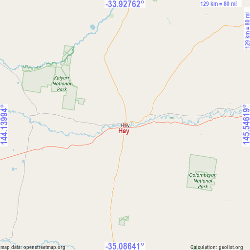
Hay GPS coordinates[2]
34° 30' 32.508" South, 144° 50' 35.016" East
| Map corner | latitude | longitude |
|---|---|---|
| Upper-left | -33.92762°, | 144.13994° |
| Center: | -34.50903°, | 144.84306° |
| Lower-right: | -35.08641°, | 145.54619° |
| Map W x H: | 128.8×128.8 km | = 80×80mi |
| max Lat: | -10.58257° ⇑63.4% North |
| Hay: | -34.50903° |
| min Lat: | ⇓36.6% South -43.31423° |
| min Long | Hay | max Long |
| 113.53327° | 144.84306° | 153.61246° |
| W 31.4%⇐ | ⇒68.6% E |
Elevation
Elevation of Hay is 93 m = 305 ft, and this is 29 m = 95 ft below average elevation for this country.
| Max E: |
1715 m = 5627 ft | 31.8% |
| Avg. | 122 m = 400 ft | |
| Hay | 93 m = 305 ft | |
Min E: |
-2 m = -7 ft | 68.2% |
See also: Australia elevation on elevation.city.
Geographical zone
Hay is located in South temperate zone (between Tropic of Capricorn and the Antarctic Circle). Distance of this Southern Tropic circle is 1231.1 km =765 mi to North.| Distance of | km | miles | from Hay |
|---|---|---|---|
| Equator | 3837 | 2384.2 | to North |
| Tropic Capricorn | 1231.1 | 765 | to North |
| Antarctic Circle | 3564.1 | 2214.6 | to South |
| South Pole | 6170 | 3833.9 | to South |


Nearby cities:
15 places around Hay: (largest is in red/bold)
• Balranald
118.2 km =73.4 mi,  263°
263°
• Barham
140.2 km =87.1 mi,  207°
207°
• Bilbul
121.9 km =75.7 mi,  77°
77°
• Coleambally
100.4 km =62.4 mi,  109°
109°
• Darlington Point
106.1 km =65.9 mi,  93°
93°
• Deniliquin
114.2 km =71 mi,  174°
174°
• Griffith
113.5 km =70.5 mi, 77°
• Hanwood
111.7 km =69.4 mi, 79°
• Hillston
130.7 km =81.2 mi,  29°
29°
• Jerilderie
124.2 km =77.2 mi,  139°
139°
• Koondrook
140.9 km =87.6 mi, 207°
• Lake Wyangan
112.4 km =69.8 mi,  74°
74°
• Tharbogang
108.9 km =67.7 mi, 75°
• Yenda
128.2 km =79.7 mi, 76°
• Yoogali
116.2 km =72.2 mi, 78°
Sources, notices
• [Note1] Compared only with cities in Australia existing in our database
• [Src1] Map data: © OpenStreetMap contributors (CC-BY-SA)
• [Src2] Other city data from geonames.org with taken over terms of usage.
• [Src3] Geographical zone / Annual Mean Temperature by Robert A. Rohde @ Wikipedia
