Balranald geodata
Balranald (New South Wales) is a populated place; located in Australia in Australia/Sydney (GMT+11) time zone. With population of 1,446 people, there are 3323 cities with bigger population in this country. Compared to other cities in Australia, 64.4% of cities are located further ↑North; 73.7% of cities are located further →East and 60.3% of cities have lower elevation than Balranald. Note1


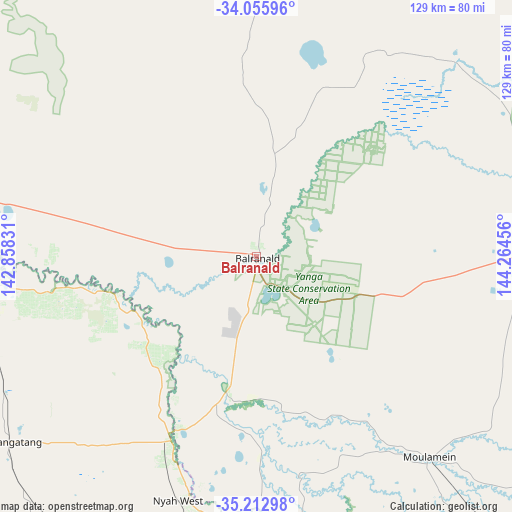
Balranald GPS coordinates[2]
34° 38' 11.364" South, 143° 33' 41.148" East
| Map corner | latitude | longitude |
|---|---|---|
| Upper-left | -34.05596°, | 142.85831° |
| Center: | -34.63649°, | 143.56143° |
| Lower-right: | -35.21298°, | 144.26456° |
| Map W x H: | 128.6×128.6 km | = 79.9×79.9mi |
| max Lat: | -10.58257° ⇑64.4% North |
| Balranald: | -34.63649° |
| min Lat: | ⇓35.6% South -43.31423° |
| min Long | Balranald | max Long |
| 113.53327° | 143.56143° | 153.61246° |
| W 26.3%⇐ | ⇒73.7% E |
Elevation
Elevation of Balranald is 65 m = 213 ft, and this is 57 m = 187 ft below average elevation for this country.
| Max E: |
1715 m = 5627 ft | 39.7% |
| Avg. | 122 m = 400 ft | |
| Balranald | 65 m = 213 ft | |
Min E: |
-2 m = -7 ft | 60.3% |
See also: Australia elevation on elevation.city.
Geographical zone
Balranald is located in South temperate zone (between Tropic of Capricorn and the Antarctic Circle). Distance of this Southern Tropic circle is 1245.3 km =773.8 mi to North.| Distance of | km | miles | from Balranald |
|---|---|---|---|
| Equator | 3851.2 | 2393 | to North |
| Tropic Capricorn | 1245.3 | 773.8 | to North |
| Antarctic Circle | 3550 | 2205.9 | to South |
| South Pole | 6155.8 | 3825 | to South |


Nearby cities:
15 places around Balranald: (largest is in red/bold)
• Barham
121.6 km =75.6 mi,  154°
154°
• Euston
75.1 km =46.7 mi,  275°
275°
• Gol Gol
133.2 km =82.8 mi,  292°
292°
• Hay
118.2 km =73.4 mi,  83°
83°
• Kerang
126.4 km =78.5 mi,  165°
165°
• Koondrook
122 km =75.8 mi,  155°
155°
• Lake Boga
92.1 km =57.2 mi,  175°
175°
• Nichols Point
132.2 km =82.1 mi, 290°
• Nyah
62.2 km =38.6 mi,  195°
195°
• Nyah West
64 km =39.8 mi, 197°
• Ouyen
123.1 km =76.5 mi,  246°
246°
• Red Cliffs
130.9 km =81.3 mi, 286°
• Robinvale
72.5 km =45 mi,  274°
274°
• Sea Lake
116.2 km =72.2 mi,  213°
213°
• Swan Hill
78 km =48.5 mi, 180°
Sources, notices
• [Note1] Compared only with cities in Australia existing in our database
• [Src1] Map data: © OpenStreetMap contributors (CC-BY-SA)
• [Src2] Other city data from geonames.org with taken over terms of usage.
• [Src3] Geographical zone / Annual Mean Temperature by Robert A. Rohde @ Wikipedia
