Goulburn geodata
Goulburn (New South Wales) is a populated place; located in Australia in Australia/Sydney (GMT+11) time zone. With population of 22,645 people, there are 129 cities with bigger population in this country. Compared to other cities in Australia, 65.3% of cities are located further ↑North; 56.5% of cities are located further ←West and 97.3% of cities have lower elevation than Goulburn. Note1


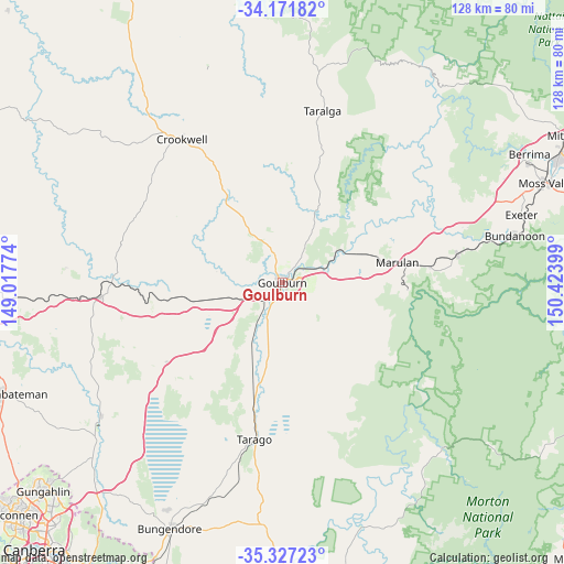
Goulburn GPS coordinates[2]
34° 45' 5.58" South, 149° 43' 15.096" East
| Map corner | latitude | longitude |
|---|---|---|
| Upper-left | -34.17182°, | 149.01774° |
| Center: | -34.75155°, | 149.72086° |
| Lower-right: | -35.32723°, | 150.42399° |
| Map W x H: | 128.5×128.5 km | = 79.8×79.8mi |
| max Lat: | -10.58257° ⇑65.3% North |
| Goulburn: | -34.75155° |
| min Lat: | ⇓34.7% South -43.31423° |
| min Long | Goulburn | max Long |
| 113.53327° | 149.72086° | 153.61246° |
| W 56.5%⇐ | ⇒43.5% E |
Elevation
Elevation of Goulburn is 642 m = 2106 ft, and this is 520 m = 1706 ft above average elevation for this country.
| Max E: |
1715 m = 5627 ft | 2.7% |
| Goulburn | 642 m 2106 ft | |
| Avg. | 122 m = 400 ft | |
Min E: |
-2 m = -7 ft | 97.3% |
See also: Australia elevation on elevation.city.
Geographical zone
Goulburn is located in South temperate zone (between Tropic of Capricorn and the Antarctic Circle). Distance of this Southern Tropic circle is 1258.1 km =781.7 mi to North.| Distance of | km | miles | from Goulburn |
|---|---|---|---|
| Equator | 3864 | 2401 | to North |
| Tropic Capricorn | 1258.1 | 781.7 | to North |
| Antarctic Circle | 3537.2 | 2197.9 | to South |
| South Pole | 6143.1 | 3817.1 | to South |


Nearby cities:
15 places around Goulburn: (largest is in red/bold)
• Berrima
63.7 km =39.6 mi,  62°
62°
• Bundanoon
53.6 km =33.3 mi,  78°
78°
• Bungendore
61.4 km =38.2 mi,  204°
204°
• Bywong
58.2 km =36.2 mi,  217°
217°
• Crookwell
39.7 km =24.7 mi,  324°
324°
• Exeter
57 km =35.4 mi,  74°
74°
• Gundaroo
53.2 km =33.1 mi,  233°
233°
• Gunning
41.7 km =25.9 mi,  265°
265°
• Marulan
26.8 km =16.7 mi, 79°
• Moss Vale
63.4 km =39.4 mi, 69°
• New Berrima
62.6 km =38.9 mi, 63°
• Sutton
63 km =39.1 mi, 222°
• Tallong
33.3 km =20.7 mi, 83°
• Wamboin
65.8 km =40.9 mi,  212°
212°
• Wingello
40.5 km =25.2 mi, 81°
Sources, notices
• [Note1] Compared only with cities in Australia existing in our database
• [Src1] Map data: © OpenStreetMap contributors (CC-BY-SA)
• [Src2] Other city data from geonames.org with taken over terms of usage.
• [Src3] Geographical zone / Annual Mean Temperature by Robert A. Rohde @ Wikipedia
