Dunedoo geodata
Dunedoo (New South Wales) is a populated place; located in Australia in Australia/Sydney (GMT+11) time zone. With population of 1,250 people, there are 3519 cities with bigger population in this country. Compared to other cities in Australia, 64.9% of cities are located further ↓South; 56% of cities are located further ←West and 90.2% of cities have lower elevation than Dunedoo. Note1


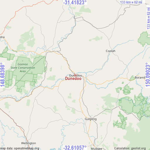
Dunedoo GPS coordinates[2]
32° 0' 58.824" South, 149° 23' 13.56" East
| Map corner | latitude | longitude |
|---|---|---|
| Upper-left | -31.41823°, | 148.68398° |
| Center: | -32.01634°, | 149.3871° |
| Lower-right: | -32.61057°, | 150.09023° |
| Map W x H: | 132.6×132.6 km | = 82.4×82.4mi |
| max Lat: | -10.58257° ⇑35.1% North |
| Dunedoo: | -32.01634° |
| min Lat: | ⇓64.9% South -43.31423° |
| min Long | Dunedoo | max Long |
| 113.53327° | 149.3871° | 153.61246° |
| W 56%⇐ | ⇒44% E |
Elevation
Elevation of Dunedoo is 384 m = 1260 ft, and this is 262 m = 860 ft above average elevation for this country.
| Max E: |
1715 m = 5627 ft | 9.8% |
| Dunedoo | 384 m 1260 ft | |
| Avg. | 122 m = 400 ft | |
Min E: |
-2 m = -7 ft | 90.2% |
See also: Australia elevation on elevation.city.
Geographical zone
Dunedoo is located in South temperate zone (between Tropic of Capricorn and the Antarctic Circle). Distance of this Southern Tropic circle is 954 km =592.8 mi to North.| Distance of | km | miles | from Dunedoo |
|---|---|---|---|
| Equator | 3559.9 | 2212 | to North |
| Tropic Capricorn | 954 | 592.8 | to North |
| Antarctic Circle | 3841.3 | 2386.9 | to South |
| South Pole | 6447.2 | 4006.1 | to South |


Nearby cities:
15 places around Dunedoo: (largest is in red/bold)
• Binnaway
51.6 km =32.1 mi,  359°
359°
• Cooks Gap
48.6 km =30.2 mi,  141°
141°
• Coolah
37.4 km =23.2 mi,  55°
55°
• Coonabarabran
82.8 km =51.4 mi,  352°
352°
• Dubbo
77.8 km =48.3 mi,  251°
251°
• Eulomogo
71.9 km =44.7 mi, 247°
• Geurie
67.6 km =42 mi,  230°
230°
• Gilgandra
76.3 km =47.4 mi,  296°
296°
• Gulgong
40.8 km =25.4 mi,  160°
160°
• Mendooran
33 km =20.5 mi,  310°
310°
• Montefiores
71.6 km =44.5 mi,  216°
216°
• Mudgee
67 km =41.6 mi, 163°
• Wellington
73 km =45.4 mi,  214°
214°
• Wongarbon
68.8 km =42.8 mi,  239°
239°
• Wuuluman
65.9 km =40.9 mi, 205°
Sources, notices
• [Note1] Compared only with cities in Australia existing in our database
• [Src1] Map data: © OpenStreetMap contributors (CC-BY-SA)
• [Src2] Other city data from geonames.org with taken over terms of usage.
• [Src3] Geographical zone / Annual Mean Temperature by Robert A. Rohde @ Wikipedia
