Coonamble geodata
Coonamble (New South Wales) is a populated place; located in Australia in Australia/Sydney (GMT+11) time zone. With population of 2,747 people, there are 2414 cities with bigger population in this country. Compared to other cities in Australia, 70.9% of cities are located further ↓South; 51.6% of cities are located further ←West and 80.1% of cities have lower elevation than Coonamble. Note1


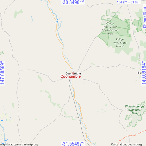
Coonamble GPS coordinates[2]
30° 57' 14.004" South, 148° 23' 19.716" East
| Map corner | latitude | longitude |
|---|---|---|
| Upper-left | -30.34901°, | 147.68569° |
| Center: | -30.95389°, | 148.38881° |
| Lower-right: | -31.55497°, | 149.09194° |
| Map W x H: | 134.1×134.1 km | = 83.3×83.3mi |
| max Lat: | -10.58257° ⇑29.1% North |
| Coonamble: | -30.95389° |
| min Lat: | ⇓70.9% South -43.31423° |
| min Long | Coonamble | max Long |
| 113.53327° | 148.38881° | 153.61246° |
| W 51.6%⇐ | ⇒48.4% E |
Elevation
Elevation of Coonamble is 182 m = 597 ft, and this is 60 m = 197 ft above average elevation for this country.
| Max E: |
1715 m = 5627 ft | 19.9% |
| Coonamble | 182 m 597 ft | |
| Avg. | 122 m = 400 ft | |
Min E: |
-2 m = -7 ft | 80.1% |
See also: Australia elevation on elevation.city.
Geographical zone
Coonamble is located in South temperate zone (between Tropic of Capricorn and the Antarctic Circle). Distance of this Southern Tropic circle is 835.8 km =519.3 mi to North.| Distance of | km | miles | from Coonamble |
|---|---|---|---|
| Equator | 3441.7 | 2138.6 | to North |
| Tropic Capricorn | 835.8 | 519.3 | to North |
| Antarctic Circle | 3959.4 | 2460.3 | to South |
| South Pole | 6565.3 | 4079.5 | to South |


Nearby cities:
15 places around Coonamble: (largest is in red/bold)
• Baradine
64.9 km =40.3 mi,  89°
89°
• Binnaway
115.2 km =71.6 mi,  125°
125°
• Coonabarabran
92.1 km =57.2 mi,  112°
112°
• Dubbo
144.8 km =90 mi,  171°
171°
• Eulomogo
148.6 km =92.3 mi, 169°
• Gilgandra
88.2 km =54.8 mi,  162°
162°
• Gulargambone
43.1 km =26.8 mi, 169°
• Mendooran
119.1 km =74 mi,  144°
144°
• Narrabri
150.6 km =93.6 mi,  62°
62°
• Narromine
142.7 km =88.7 mi,  185°
185°
• Nyngan
132.3 km =82.2 mi,  239°
239°
• Trangie
125.8 km =78.2 mi,  197°
197°
• Walgett
106.6 km =66.2 mi,  345°
345°
• Warren
98.5 km =61.2 mi,  212°
212°
• Wee Waa
129.1 km =80.2 mi,  51°
51°
Sources, notices
• [Note1] Compared only with cities in Australia existing in our database
• [Src1] Map data: © OpenStreetMap contributors (CC-BY-SA)
• [Src2] Other city data from geonames.org with taken over terms of usage.
• [Src3] Geographical zone / Annual Mean Temperature by Robert A. Rohde @ Wikipedia
