Eidsvold geodata
Eidsvold (Queensland) is a populated place; located in Australia in Australia/Brisbane (GMT+10) time zone. With population of 564 people, there are 4670 cities with bigger population in this country. Compared to other cities in Australia, 89% of cities are located further ↓South; 70.7% of cities are located further ←West and 81.1% of cities have lower elevation than Eidsvold. Note1


Eidsvold GPS coordinates[2]
25° 22' 18.048" South, 151° 7' 17.22" East
| Map corner | latitude | longitude |
|---|---|---|
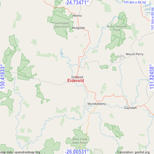
| Upper-left | -24.73471°, | 150.41833° |
| Center: | -25.37168°, | 151.12145° |
| Lower-right: | -26.00531°, | 151.82458° |
| Map W x H: | 141.3×141.3 km | = 87.8×87.8mi |
| max Lat: | -10.58257° ⇑11% North |
| Eidsvold: | -25.37168° |
| min Lat: | ⇓89% South -43.31423° |
| min Long | Eidsvold | max Long |
| 113.53327° | 151.12145° | 153.61246° |
| W 70.7%⇐ | ⇒29.3% E |
Elevation
Elevation of Eidsvold is 193 m = 633 ft, and this is 71 m = 233 ft above average elevation for this country.
| Max E: |
1715 m = 5627 ft | 18.9% |
| Eidsvold | 193 m 633 ft | |
| Avg. | 122 m = 400 ft | |
Min E: |
-2 m = -7 ft | 81.1% |
See also: Australia elevation on elevation.city.
Geographical zone
Eidsvold is located in South temperate zone (between Tropic of Capricorn and the Antarctic Circle). Distance of this Southern Tropic circle is 215.1 km =133.7 mi to North.| Distance of | km | miles | from Eidsvold |
|---|---|---|---|
| Equator | 2821.1 | 1752.9 | to North |
| Tropic Capricorn | 215.1 | 133.7 | to North |
| Antarctic Circle | 4580.1 | 2845.9 | to South |
| South Pole | 7186 | 4465.2 | to South |


Nearby cities:
15 places around Eidsvold: (largest is in red/bold)
• Apple Tree Creek
113.1 km =70.3 mi,  81°
81°
• Biggenden
94 km =58.4 mi,  99°
99°
• Bucca
113.4 km =70.5 mi,  60°
60°
• Childers
117.3 km =72.9 mi, 82°
• Gayndah
56.7 km =35.2 mi,  119°
119°
• Gin Gin
94.1 km =58.5 mi, 63°
• Miriam Vale
123.9 km =77 mi,  21°
21°
• Monto
56.4 km =35 mi,  0°
0°
• Mount Perry
57 km =35.4 mi,  67°
67°
• Mundubbera
30.5 km =19 mi,  143°
143°
• North Isis
116.9 km =72.6 mi, 79°
• South Bingera
119.6 km =74.3 mi, 67°
• South Kolan
116.1 km =72.1 mi, 65°
• Thangool
112.9 km =70.2 mi,  330°
330°
• Theodore
115.5 km =71.8 mi,  294°
294°
Sources, notices
• [Note1] Compared only with cities in Australia existing in our database
• [Src1] Map data: © OpenStreetMap contributors (CC-BY-SA)
• [Src2] Other city data from geonames.org with taken over terms of usage.
• [Src3] Geographical zone / Annual Mean Temperature by Robert A. Rohde @ Wikipedia
