Gayndah geodata
Gayndah (Queensland) is a populated place; located in Australia in Australia/Brisbane (GMT+10) time zone. With population of 2,029 people, there are 2883 cities with bigger population in this country. Compared to other cities in Australia, 88.8% of cities are located further ↓South; 79.2% of cities are located further ←West and 71.1% of cities have lower elevation than Gayndah. Note1


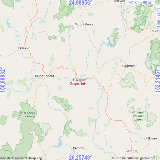
Gayndah GPS coordinates[2]
25° 37' 30.792" South, 151° 36' 41.184" East
| Map corner | latitude | longitude |
|---|---|---|
| Upper-left | -24.98958°, | 150.90832° |
| Center: | -25.62522°, | 151.61144° |
| Lower-right: | -26.25749°, | 152.31457° |
| Map W x H: | 141×141 km | = 87.6×87.6mi |
| max Lat: | -10.58257° ⇑11.2% North |
| Gayndah: | -25.62522° |
| min Lat: | ⇓88.8% South -43.31423° |
| min Long | Gayndah | max Long |
| 113.53327° | 151.61144° | 153.61246° |
| W 79.2%⇐ | ⇒20.8% E |
Elevation
Elevation of Gayndah is 109 m = 358 ft, and this is 13 m = 43 ft below average elevation for this country.
| Max E: |
1715 m = 5627 ft | 28.9% |
| Avg. | 122 m = 400 ft | |
| Gayndah | 109 m = 358 ft | |
Min E: |
-2 m = -7 ft | 71.1% |
See also: Australia elevation on elevation.city.
Geographical zone
Gayndah is located in South temperate zone (between Tropic of Capricorn and the Antarctic Circle). Distance of this Southern Tropic circle is 243.3 km =151.2 mi to North.| Distance of | km | miles | from Gayndah |
|---|---|---|---|
| Equator | 2849.3 | 1770.5 | to North |
| Tropic Capricorn | 243.3 | 151.2 | to North |
| Antarctic Circle | 4551.9 | 2828.4 | to South |
| South Pole | 7157.8 | 4447.6 | to South |


Nearby cities:
15 places around Gayndah: (largest is in red/bold)
• Apple Tree Creek
77.2 km =48 mi,  53°
53°
• Biggenden
45.4 km =28.2 mi,  73°
73°
• Cherbourg
81.6 km =50.7 mi,  155°
155°
• Childers
79.7 km =49.5 mi,  57°
57°
• Eidsvold
56.7 km =35.2 mi,  299°
299°
• Gin Gin
78.4 km =48.7 mi,  26°
26°
• Goomeri
77.1 km =47.9 mi,  143°
143°
• Kilkivan
80.7 km =50.1 mi,  129°
129°
• Mount Perry
49.7 km =30.9 mi,  4°
4°
• Mundubbera
31.2 km =19.4 mi,  276°
276°
• Murgon
76 km =47.2 mi,  154°
154°
• North Isis
82.4 km =51.2 mi, 52°
• Redridge
90.7 km =56.4 mi, 56°
• South Kolan
95.2 km =59.2 mi,  35°
35°
• Wondai
81.3 km =50.5 mi, 161°
Sources, notices
• [Note1] Compared only with cities in Australia existing in our database
• [Src1] Map data: © OpenStreetMap contributors (CC-BY-SA)
• [Src2] Other city data from geonames.org with taken over terms of usage.
• [Src3] Geographical zone / Annual Mean Temperature by Robert A. Rohde @ Wikipedia
