Mundubbera geodata
Mundubbera (Queensland) is a populated place; located in Australia in Australia/Brisbane (GMT+10) time zone. With population of 1,345 people, there are 3424 cities with bigger population in this country. Compared to other cities in Australia, 88.8% of cities are located further ↓South; 75.8% of cities are located further ←West and 74.7% of cities have lower elevation than Mundubbera. Note1


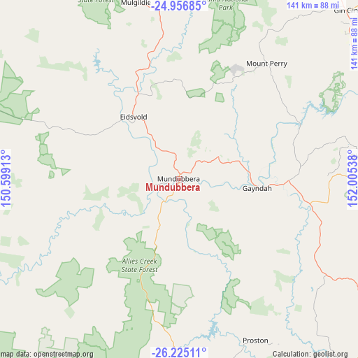
Mundubbera GPS coordinates[2]
25° 35' 33.576" South, 151° 18' 8.1" East
| Map corner | latitude | longitude |
|---|---|---|
| Upper-left | -24.95685°, | 150.59913° |
| Center: | -25.59266°, | 151.30225° |
| Lower-right: | -26.22511°, | 152.00538° |
| Map W x H: | 141×141 km | = 87.6×87.6mi |
| max Lat: | -10.58257° ⇑11.2% North |
| Mundubbera: | -25.59266° |
| min Lat: | ⇓88.8% South -43.31423° |
| min Long | Mundubbera | max Long |
| 113.53327° | 151.30225° | 153.61246° |
| W 75.8%⇐ | ⇒24.2% E |
Elevation
Elevation of Mundubbera is 128 m = 420 ft, and this is 6 m = 20 ft above average elevation for this country.
| Max E: |
1715 m = 5627 ft | 25.3% |
| Mundubbera | 128 m 420 ft | |
| Avg. | 122 m = 400 ft | |
Min E: |
-2 m = -7 ft | 74.7% |
See also: Australia elevation on elevation.city.
Geographical zone
Mundubbera is located in South temperate zone (between Tropic of Capricorn and the Antarctic Circle). Distance of this Southern Tropic circle is 239.7 km =148.9 mi to North.| Distance of | km | miles | from Mundubbera |
|---|---|---|---|
| Equator | 2845.6 | 1768.2 | to North |
| Tropic Capricorn | 239.7 | 148.9 | to North |
| Antarctic Circle | 4555.5 | 2830.7 | to South |
| South Pole | 7161.4 | 4449.9 | to South |


Nearby cities:
15 places around Mundubbera: (largest is in red/bold)
• Apple Tree Creek
102.4 km =63.6 mi,  65°
65°
• Biggenden
75.1 km =46.7 mi,  82°
82°
• Bucca
113.8 km =70.7 mi,  44°
44°
• Cherbourg
101.3 km =62.9 mi,  140°
140°
• Childers
105.7 km =65.7 mi, 68°
• Eidsvold
30.5 km =19 mi,  323°
323°
• Gayndah
31.2 km =19.4 mi,  96°
96°
• Gin Gin
93.7 km =58.2 mi, 44°
• Goomeri
101 km =62.8 mi,  130°
130°
• Kilkivan
108.2 km =67.2 mi,  120°
120°
• Monto
82.9 km =51.5 mi,  347°
347°
• Mount Perry
57.6 km =35.8 mi, 36°
• Murgon
96.3 km =59.8 mi, 138°
• North Isis
107.1 km =66.5 mi,  64°
64°
• Wondai
98.7 km =61.3 mi, 144°
Sources, notices
• [Note1] Compared only with cities in Australia existing in our database
• [Src1] Map data: © OpenStreetMap contributors (CC-BY-SA)
• [Src2] Other city data from geonames.org with taken over terms of usage.
• [Src3] Geographical zone / Annual Mean Temperature by Robert A. Rohde @ Wikipedia
