Naracoorte geodata
Naracoorte (South Australia) is a populated place; located in Australia in Australia/Adelaide (GMT+10.5) time zone. With population of 5,876 people, there are 1237 cities with bigger population in this country. Compared to other cities in Australia, 81.4% of cities are located further ↑North; 75.7% of cities are located further →East and 56.9% of cities have lower elevation than Naracoorte. Note1


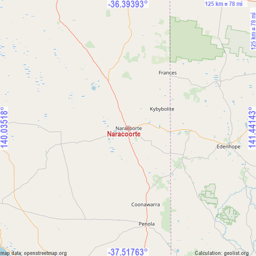
Naracoorte GPS coordinates[2]
36° 57' 28.26" South, 140° 44' 17.88" East
| Map corner | latitude | longitude |
|---|---|---|
| Upper-left | -36.39393°, | 140.03518° |
| Center: | -36.95785°, | 140.7383° |
| Lower-right: | -37.51763°, | 141.44143° |
| Map W x H: | 124.9×124.9 km | = 77.6×77.6mi |
| max Lat: | -10.58257° ⇑81.4% North |
| Naracoorte: | -36.95785° |
| min Lat: | ⇓18.6% South -43.31423° |
| min Long | Naracoorte | max Long |
| 113.53327° | 140.7383° | 153.61246° |
| W 24.3%⇐ | ⇒75.7% E |
Elevation
Elevation of Naracoorte is 57 m = 187 ft, and this is 65 m = 213 ft below average elevation for this country.
| Max E: |
1715 m = 5627 ft | 43.1% |
| Avg. | 122 m = 400 ft | |
| Naracoorte | 57 m = 187 ft | |
Min E: |
-2 m = -7 ft | 56.9% |
See also: Australia elevation on elevation.city.
Geographical zone
Naracoorte is located in South temperate zone (between Tropic of Capricorn and the Antarctic Circle). Distance of this Southern Tropic circle is 1503.4 km =934.2 mi to North.| Distance of | km | miles | from Naracoorte |
|---|---|---|---|
| Equator | 4109.3 | 2553.4 | to North |
| Tropic Capricorn | 1503.4 | 934.2 | to North |
| Antarctic Circle | 3291.8 | 2045.4 | to South |
| South Pole | 5897.7 | 3664.7 | to South |


Nearby cities:
15 places around Naracoorte: (largest is in red/bold)
• Beachport
86.6 km =53.8 mi,  227°
227°
• Bordertown
72.4 km =45 mi,  2°
2°
• Casterton
91.2 km =56.7 mi,  139°
139°
• Compton
95.5 km =59.3 mi,  183°
183°
• Edenhope
50.3 km =31.3 mi,  100°
100°
• Glencoe
83.2 km =51.7 mi,  187°
187°
• Kaniva
78.5 km =48.8 mi,  34°
34°
• Kingston South East
80.1 km =49.8 mi,  280°
280°
• Lucindale
32.8 km =20.4 mi,  267°
267°
• Millicent
78.6 km =48.8 mi,  205°
205°
• Nangwarry
65.7 km =40.8 mi,  174°
174°
• Penola
47.2 km =29.3 mi, 169°
• Robe
89.8 km =55.8 mi,  255°
255°
• Sutton Town
93.7 km =58.2 mi, 177°
• Worrolong
94.8 km =58.9 mi, 174°
Sources, notices
• [Note1] Compared only with cities in Australia existing in our database
• [Src1] Map data: © OpenStreetMap contributors (CC-BY-SA)
• [Src2] Other city data from geonames.org with taken over terms of usage.
• [Src3] Geographical zone / Annual Mean Temperature by Robert A. Rohde @ Wikipedia
