Edenhope geodata
Edenhope (Victoria) is a populated place; located in Australia in Australia/Melbourne (GMT+11) time zone. With population of 913 people, there are 3958 cities with bigger population in this country. Compared to other cities in Australia, 81.6% of cities are located further ↑North; 75.4% of cities are located further →East and 78.6% of cities have lower elevation than Edenhope. Note1


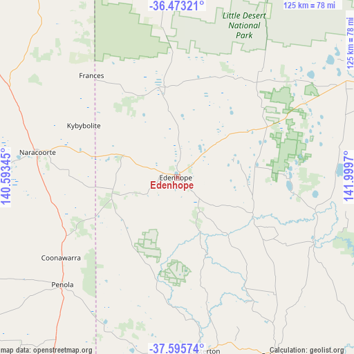
Edenhope GPS coordinates[2]
37° 2' 11.58" South, 141° 17' 47.652" East
| Map corner | latitude | longitude |
|---|---|---|
| Upper-left | -36.47321°, | 140.59345° |
| Center: | -37.03655°, | 141.29657° |
| Lower-right: | -37.59574°, | 141.9997° |
| Map W x H: | 124.8×124.8 km | = 77.5×77.5mi |
| max Lat: | -10.58257° ⇑81.6% North |
| Edenhope: | -37.03655° |
| min Lat: | ⇓18.4% South -43.31423° |
| min Long | Edenhope | max Long |
| 113.53327° | 141.29657° | 153.61246° |
| W 24.6%⇐ | ⇒75.4% E |
Elevation
Elevation of Edenhope is 164 m = 538 ft, and this is 42 m = 138 ft above average elevation for this country.
| Max E: |
1715 m = 5627 ft | 21.4% |
| Edenhope | 164 m 538 ft | |
| Avg. | 122 m = 400 ft | |
Min E: |
-2 m = -7 ft | 78.6% |
See also: Australia elevation on elevation.city.
Geographical zone
Edenhope is located in South temperate zone (between Tropic of Capricorn and the Antarctic Circle). Distance of this Southern Tropic circle is 1512.2 km =939.6 mi to North.| Distance of | km | miles | from Edenhope |
|---|---|---|---|
| Equator | 4118.1 | 2558.9 | to North |
| Tropic Capricorn | 1512.2 | 939.6 | to North |
| Antarctic Circle | 3283.1 | 2040 | to South |
| South Pole | 5889 | 3659.3 | to South |


Nearby cities:
15 places around Edenhope: (largest is in red/bold)
• Bordertown
93.6 km =58.2 mi,  329°
329°
• Casterton
61.7 km =38.3 mi,  171°
171°
• Coleraine
71.5 km =44.4 mi,  150°
150°
• Dimboola
92 km =57.2 mi,  45°
45°
• Glencoe
95.1 km =59.1 mi,  219°
219°
• Haven
85.5 km =53.1 mi,  68°
68°
• Horsham
88.1 km =54.7 mi, 65°
• Kaniva
73.3 km =45.5 mi,  356°
356°
• Lucindale
82.6 km =51.3 mi,  274°
274°
• Nangwarry
70.9 km =44.1 mi, 216°
• Naracoorte
50.3 km =31.3 mi,  280°
280°
• Nhill
84.3 km =52.4 mi,  21°
21°
• Penola
55.5 km =34.5 mi,  227°
227°
• Sutton Town
96.2 km =59.8 mi,  208°
208°
• Worrolong
94.3 km =58.6 mi,  204°
204°
Sources, notices
• [Note1] Compared only with cities in Australia existing in our database
• [Src1] Map data: © OpenStreetMap contributors (CC-BY-SA)
• [Src2] Other city data from geonames.org with taken over terms of usage.
• [Src3] Geographical zone / Annual Mean Temperature by Robert A. Rohde @ Wikipedia
