Lucindale geodata
Lucindale (South Australia) is a populated place; located in Australia in Australia/Adelaide (GMT+10.5) time zone. With population of 524 people, there are 4801 cities with bigger population in this country. Compared to other cities in Australia, 81.4% of cities are located further ↑North; 76% of cities are located further →East and 61.1% of cities have higher elevation than Lucindale. Note1


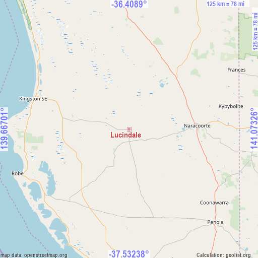
Lucindale GPS coordinates[2]
36° 58' 21.756" South, 140° 22' 12.468" East
| Map corner | latitude | longitude |
|---|---|---|
| Upper-left | -36.4089°, | 139.66701° |
| Center: | -36.97271°, | 140.37013° |
| Lower-right: | -37.53238°, | 141.07326° |
| Map W x H: | 124.9×124.9 km | = 77.6×77.6mi |
| max Lat: | -10.58257° ⇑81.4% North |
| Lucindale: | -36.97271° |
| min Lat: | ⇓18.6% South -43.31423° |
| min Long | Lucindale | max Long |
| 113.53327° | 140.37013° | 153.61246° |
| W 24%⇐ | ⇒76% E |
Elevation
Elevation of Lucindale is 31 m = 102 ft, and this is 91 m = 299 ft below average elevation for this country.
| Max E: |
1715 m = 5627 ft | 61.1% |
| Avg. | 122 m = 400 ft | |
| Lucindale | 31 m = 102 ft | |
Min E: |
-2 m = -7 ft | 38.9% |
See also: Australia elevation on elevation.city.
Geographical zone
Lucindale is located in South temperate zone (between Tropic of Capricorn and the Antarctic Circle). Distance of this Southern Tropic circle is 1505.1 km =935.2 mi to North.| Distance of | km | miles | from Lucindale |
|---|---|---|---|
| Equator | 4111 | 2554.5 | to North |
| Tropic Capricorn | 1505.1 | 935.2 | to North |
| Antarctic Circle | 3290.2 | 2044.4 | to South |
| South Pole | 5896.1 | 3663.7 | to South |


Nearby cities:
15 places around Lucindale: (largest is in red/bold)
• Beachport
64.7 km =40.2 mi,  209°
209°
• Bordertown
82.2 km =51.1 mi,  25°
25°
• Compton
97.5 km =60.6 mi,  163°
163°
• Edenhope
82.6 km =51.3 mi,  94°
94°
• Glencoe
83.8 km =52.1 mi, 164°
• Kaniva
102 km =63.4 mi,  49°
49°
• Keith
97.1 km =60.3 mi,  359°
359°
• Kingston South East
48.7 km =30.3 mi,  288°
288°
• Millicent
69.1 km =42.9 mi,  181°
181°
• Nangwarry
74.9 km =46.5 mi,  148°
148°
• Naracoorte
32.8 km =20.4 mi, 87°
• Penola
60.9 km =37.8 mi,  137°
137°
• Robe
58.1 km =36.1 mi,  248°
248°
• Sutton Town
99 km =61.5 mi, 158°
• Worrolong
101.8 km =63.3 mi, 155°
Sources, notices
• [Note1] Compared only with cities in Australia existing in our database
• [Src1] Map data: © OpenStreetMap contributors (CC-BY-SA)
• [Src2] Other city data from geonames.org with taken over terms of usage.
• [Src3] Geographical zone / Annual Mean Temperature by Robert A. Rohde @ Wikipedia
