Clermont geodata
Clermont (Queensland) is a populated place; located in Australia in Australia/Brisbane (GMT+10) time zone. With population of 3,401 people, there are 2027 cities with bigger population in this country. Compared to other cities in Australia, 92.5% of cities are located further ↓South; 50.4% of cities are located further ←West and 85.8% of cities have lower elevation than Clermont. Note1


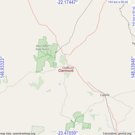
Clermont GPS coordinates[2]
22° 49' 26.652" South, 147° 38' 10.86" East
| Map corner | latitude | longitude |
|---|---|---|
| Upper-left | -22.17447°, | 146.93323° |
| Center: | -22.82407°, | 147.63635° |
| Lower-right: | -23.47059°, | 148.33948° |
| Map W x H: | 144.1×144.1 km | = 89.5×89.5mi |
| max Lat: | -10.58257° ⇑7.5% North |
| Clermont: | -22.82407° |
| min Lat: | ⇓92.5% South -43.31423° |
| min Long | Clermont | max Long |
| 113.53327° | 147.63635° | 153.61246° |
| W 50.4%⇐ | ⇒49.6% E |
Elevation
Elevation of Clermont is 262 m = 860 ft, and this is 140 m = 459 ft above average elevation for this country.
| Max E: |
1715 m = 5627 ft | 14.2% |
| Clermont | 262 m 860 ft | |
| Avg. | 122 m = 400 ft | |
Min E: |
-2 m = -7 ft | 85.8% |
See also: Australia elevation on elevation.city.
Geographical zone
Clermont is located in South Torrid zone (between Equator and Tropic of Capricorn). Distance of this Southern Tropic circle is 68.1 km =42.3 mi to South.| Distance of | km | miles | from Clermont |
|---|---|---|---|
| Equator | 2537.8 | 1576.9 | to North |
| Tropic Capricorn | 68.1 | 42.3 | to South |
| Antarctic Circle | 4863.4 | 3022 | to South |
| South Pole | 7469.3 | 4641.2 | to South |


Nearby cities:
15 places around Clermont: (largest is in red/bold)
• Blackwater
152.5 km =94.8 mi,  123°
123°
• Capella
49.1 km =30.5 mi,  126°
126°
• Comet
127.1 km =79 mi, 132°
• Coppabella
119 km =73.9 mi,  35°
35°
• Dysart
77.7 km =48.3 mi,  70°
70°
• Emerald
94.2 km =58.5 mi,  145°
145°
• Hail Creek
161 km =100 mi,  29°
29°
• Middlemount
108.9 km =67.7 mi,  89°
89°
• Moranbah
100.7 km =62.6 mi,  24°
24°
• Nebo
166.4 km =103.4 mi, 40°
• Rubyvale
66.4 km =41.3 mi,  174°
174°
• Sapphire
71 km =44.1 mi, 172°
• Springsure
150.7 km =93.6 mi,  162°
162°
• The Gemfields
80.2 km =49.8 mi, 168°
• Tieri
76.3 km =47.4 mi,  108°
108°
Sources, notices
• [Note1] Compared only with cities in Australia existing in our database
• [Src1] Map data: © OpenStreetMap contributors (CC-BY-SA)
• [Src2] Other city data from geonames.org with taken over terms of usage.
• [Src3] Geographical zone / Annual Mean Temperature by Robert A. Rohde @ Wikipedia
