North West Cape geodata
North West Cape (Western Australia) is a populated place; located in Australia in Australia/Perth (GMT+8) time zone. With population of 560 people, there are 4680 cities with bigger population in this country. Compared to other cities in Australia, 92.7% of cities are located further ↓South; 99.8% of cities are located further →East and 96.8% of cities have higher elevation than North West Cape. Note1


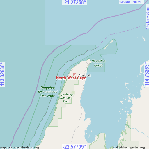
North West Cape GPS coordinates[2]
21° 55' 34.788" South, 114° 1' 46.2" East
| Map corner | latitude | longitude |
|---|---|---|
| Upper-left | -21.27258°, | 113.32638° |
| Center: | -21.92633°, | 114.0295° |
| Lower-right: | -22.57709°, | 114.73263° |
| Map W x H: | 145×145 km | = 90.1×90.1mi |
| max Lat: | -10.58257° ⇑7.3% North |
| North West Cape: | -21.92633° |
| min Lat: | ⇓92.7% South -43.31423° |
| min Long | North West Cape | max Long |
| 113.53327° | 114.0295° | 153.61246° |
| W 0.2%⇐ | ⇒99.8% E |
Elevation
Elevation of North West Cape is 5 m = 16 ft, and this is 117 m = 384 ft below average elevation for this country.
| Max E: |
1715 m = 5627 ft | 96.8% |
| Avg. | 122 m = 400 ft | |
| North West Cape | 5 m = 16 ft | |
Min E: |
-2 m = -7 ft | 3.2% |
See also: Australia elevation on elevation.city.
Geographical zone
North West Cape is located in South Torrid zone (between Equator and Tropic of Capricorn). Distance of this Southern Tropic circle is 167.9 km =104.3 mi to South.| Distance of | km | miles | from North West Cape |
|---|---|---|---|
| Equator | 2438 | 1514.9 | to North |
| Tropic Capricorn | 167.9 | 104.3 | to South |
| Antarctic Circle | 4963.2 | 3084 | to South |
| South Pole | 7569.1 | 4703.2 | to South |


Nearby cities:
15 places around North West Cape: (largest is in red/bold)
• Baynton
315.4 km =196 mi,  65°
65°
• Bulgarra
321.8 km =200 mi, 65°
• Coral Bay
137.5 km =85.4 mi,  190°
190°
• Dampier
311.4 km =193.5 mi,  63°
63°
• East Carnarvon
328.6 km =204.2 mi, 186°
• Exmouth
9.4 km =5.8 mi,  92°
92°
• Karratha
320.3 km =199 mi, 65°
• Karratha Industrial Estate
320.9 km =199.4 mi, 66°
• Kingsford
328.4 km =204.1 mi, 185°
• Millars Well
317.4 km =197.2 mi, 65°
• Morgantown
330.2 km =205.2 mi, 186°
• Nickol
315.1 km =195.8 mi, 65°
• Onslow
116.3 km =72.3 mi, 73°
• Pannawonica
238.9 km =148.4 mi,  82°
82°
• Pegs Creek
319 km =198.2 mi, 65°
Sources, notices
• [Note1] Compared only with cities in Australia existing in our database
• [Src1] Map data: © OpenStreetMap contributors (CC-BY-SA)
• [Src2] Other city data from geonames.org with taken over terms of usage.
• [Src3] Geographical zone / Annual Mean Temperature by Robert A. Rohde @ Wikipedia
