Onslow geodata
Onslow (Western Australia) is a populated place; located in Australia in Australia/Perth (GMT+8) time zone. With population of 1,157 people, there are 3631 cities with bigger population in this country. Compared to other cities in Australia, 92.8% of cities are located further ↓South; 99.1% of cities are located further →East and 93.8% of cities have higher elevation than Onslow. Note1


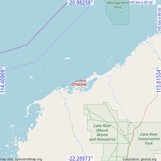
Onslow GPS coordinates[2]
21° 38' 15.504" South, 115° 6' 43.956" East
| Map corner | latitude | longitude |
|---|---|---|
| Upper-left | -20.98259°, | 114.40909° |
| Center: | -21.63764°, | 115.11221° |
| Lower-right: | -22.28973°, | 115.81534° |
| Map W x H: | 145.3×145.3 km | = 90.3×90.3mi |
| max Lat: | -10.58257° ⇑7.2% North |
| Onslow: | -21.63764° |
| min Lat: | ⇓92.8% South -43.31423° |
| min Long | Onslow | max Long |
| 113.53327° | 115.11221° | 153.61246° |
| W 0.9%⇐ | ⇒99.1% E |
Elevation
Elevation of Onslow is 7 m = 23 ft, and this is 115 m = 377 ft below average elevation for this country.
| Max E: |
1715 m = 5627 ft | 93.8% |
| Avg. | 122 m = 400 ft | |
| Onslow | 7 m = 23 ft | |
Min E: |
-2 m = -7 ft | 6.2% |
See also: Australia elevation on elevation.city.
Geographical zone
Onslow is located in South Torrid zone (between Equator and Tropic of Capricorn). Distance of this Southern Tropic circle is 200 km =124.3 mi to South.| Distance of | km | miles | from Onslow |
|---|---|---|---|
| Equator | 2405.9 | 1495 | to North |
| Tropic Capricorn | 200 | 124.3 | to South |
| Antarctic Circle | 4995.3 | 3103.9 | to South |
| South Pole | 7601.2 | 4723.2 | to South |


Nearby cities:
15 places around Onslow: (largest is in red/bold)
• Baynton
200.9 km =124.8 mi,  60°
60°
• Bulgarra
207.3 km =128.8 mi, 60°
• Coral Bay
216.3 km =134.4 mi,  219°
219°
• Dampier
198.2 km =123.2 mi, 56°
• Exmouth
107.4 km =66.7 mi,  252°
252°
• Karratha
205.7 km =127.8 mi, 60°
• Karratha Industrial Estate
206 km =128 mi, 62°
• Millars Well
202.9 km =126.1 mi, 60°
• Nickol
200.7 km =124.7 mi, 60°
• North West Cape
116.3 km =72.3 mi, 253°
• Pannawonica
125.1 km =77.7 mi,  90°
90°
• Pegs Creek
204.5 km =127.1 mi, 60°
• Roebourne
231.8 km =144 mi,  65°
65°
• Tom Price
300 km =186.4 mi,  113°
113°
• Wickham
235.8 km =146.5 mi, 62°
Sources, notices
• [Note1] Compared only with cities in Australia existing in our database
• [Src1] Map data: © OpenStreetMap contributors (CC-BY-SA)
• [Src2] Other city data from geonames.org with taken over terms of usage.
• [Src3] Geographical zone / Annual Mean Temperature by Robert A. Rohde @ Wikipedia
