West Arnhem geodata
West Arnhem (Northern Territory) is a populated place; located in Australia in Australia/Darwin (GMT+9.5) time zone. With population of 754 people, there are 4236 cities with bigger population in this country. Compared to other cities in Australia, 99.8% of cities are located further ↓South; 86.5% of cities are located further →East and 95.5% of cities have higher elevation than West Arnhem. Note1


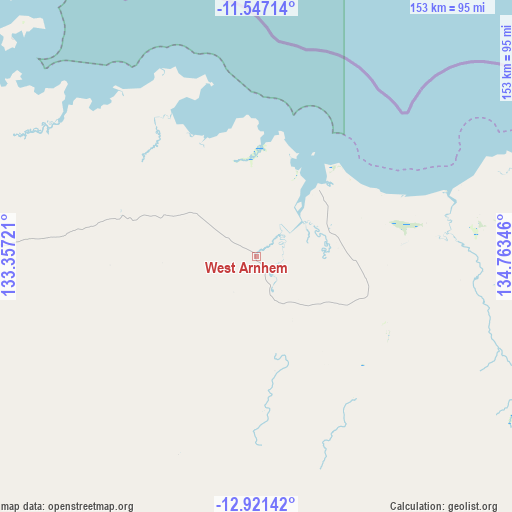
West Arnhem GPS coordinates[2]
12° 14' 6.612" South, 134° 3' 37.188" East
| Map corner | latitude | longitude |
|---|---|---|
| Upper-left | -11.54714°, | 133.35721° |
| Center: | -12.23517°, | 134.06033° |
| Lower-right: | -12.92142°, | 134.76346° |
| Map W x H: | 152.8×152.8 km | = 94.9×94.9mi |
| max Lat: | -10.58257° ⇑0.2% North |
| West Arnhem: | -12.23517° |
| min Lat: | ⇓99.8% South -43.31423° |
| min Long | West Arnhem | max Long |
| 113.53327° | 134.06033° | 153.61246° |
| W 13.5%⇐ | ⇒86.5% E |
Elevation
Elevation of West Arnhem is 6 m = 20 ft, and this is 116 m = 381 ft below average elevation for this country.
| Max E: |
1715 m = 5627 ft | 95.5% |
| Avg. | 122 m = 400 ft | |
| West Arnhem | 6 m = 20 ft | |
Min E: |
-2 m = -7 ft | 4.5% |
See also: Australia elevation on elevation.city.
Geographical zone
West Arnhem is located in South Torrid zone (between Equator and Tropic of Capricorn). Distance of this Southern Tropic circle is 1245.5 km =773.9 mi to South.| Distance of | km | miles | from West Arnhem |
|---|---|---|---|
| Equator | 1360.4 | 845.3 | to North |
| Tropic Capricorn | 1245.5 | 773.9 | to South |
| Antarctic Circle | 6040.8 | 3753.6 | to South |
| South Pole | 8646.6 | 5372.7 | to South |


Nearby cities:
15 places around West Arnhem: (largest is in red/bold)
• Alyangula
312.7 km =194.3 mi,  125°
125°
• Beswick
277.8 km =172.6 mi,  201°
201°
• Galiwinku
165.2 km =102.7 mi,  81°
81°
• Gapuwiyak
192.4 km =119.6 mi,  98°
98°
• Gunbalanya
110.1 km =68.4 mi,  264°
264°
• Jabiru
141.5 km =87.9 mi,  249°
249°
• Kakadu
186 km =115.6 mi, 247°
• Lansdowne
303.9 km =188.8 mi,  216°
216°
• Maningrida
27.7 km =17.2 mi,  41°
41°
• Marrakai
285.9 km =177.7 mi, 258°
• Milingimbi
94.5 km =58.7 mi, 80°
• Ngukurr
286.8 km =178.2 mi,  165°
165°
• Nhulunbuy
295.4 km =183.6 mi,  88°
88°
• Ramingining
95.3 km =59.2 mi, 96°
• Yirrkala
307.5 km =191.1 mi, 90°
Sources, notices
• [Note1] Compared only with cities in Australia existing in our database
• [Src1] Map data: © OpenStreetMap contributors (CC-BY-SA)
• [Src2] Other city data from geonames.org with taken over terms of usage.
• [Src3] Geographical zone / Annual Mean Temperature by Robert A. Rohde @ Wikipedia
