Santa Teresa geodata
Santa Teresa (Northern Territory) is a populated place; located in Australia in Australia/Darwin (GMT+9.5) time zone. With population of 575 people, there are 4631 cities with bigger population in this country. Compared to other cities in Australia, 90.6% of cities are located further ↓South; 86.4% of cities are located further →East and 92% of cities have lower elevation than Santa Teresa. Note1


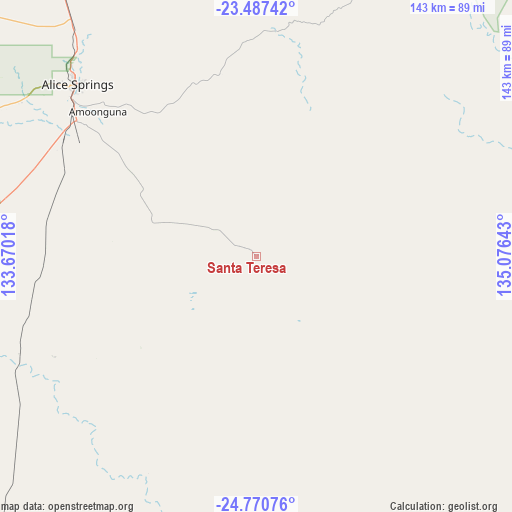
Santa Teresa GPS coordinates[2]
24° 7' 50.52" South, 134° 22' 23.88" East
| Map corner | latitude | longitude |
|---|---|---|
| Upper-left | -23.48742°, | 133.67018° |
| Center: | -24.1307°, | 134.3733° |
| Lower-right: | -24.77076°, | 135.07643° |
| Map W x H: | 142.7×142.7 km | = 88.7×88.7mi |
| max Lat: | -10.58257° ⇑9.4% North |
| Santa Teresa: | -24.1307° |
| min Lat: | ⇓90.6% South -43.31423° |
| min Long | Santa Teresa | max Long |
| 113.53327° | 134.3733° | 153.61246° |
| W 13.6%⇐ | ⇒86.4% E |
Elevation
Elevation of Santa Teresa is 441 m = 1447 ft, and this is 319 m = 1047 ft above average elevation for this country.
| Max E: |
1715 m = 5627 ft | 8% |
| Santa Teresa | 441 m 1447 ft | |
| Avg. | 122 m = 400 ft | |
Min E: |
-2 m = -7 ft | 92% |
See also: Australia elevation on elevation.city.
Geographical zone
Santa Teresa is located in South temperate zone (between Tropic of Capricorn and the Antarctic Circle). Distance of this Southern Tropic circle is 77.2 km =48 mi to North.| Distance of | km | miles | from Santa Teresa |
|---|---|---|---|
| Equator | 2683.1 | 1667.2 | to North |
| Tropic Capricorn | 77.2 | 48 | to North |
| Antarctic Circle | 4718.1 | 2931.7 | to South |
| South Pole | 7324 | 4550.9 | to South |


Nearby cities:
15 places around Santa Teresa: (largest is in red/bold)
• Alice Springs
69.3 km =43.1 mi,  314°
314°
• Alice Springs city centre
69.4 km =43.1 mi, 313°
• Araluen
71.6 km =44.5 mi, 312°
• Braitling
71.7 km =44.6 mi, 314°
• Desert Springs
67.6 km =42 mi, 313°
• East Side
69 km =42.9 mi, 314°
• Gillen
69.7 km =43.3 mi, 312°
• Hermannsburg
163.1 km =101.3 mi,  277°
277°
• Hugh
84.3 km =52.4 mi,  257°
257°
• Ilparpa
70.4 km =43.7 mi, 306°
• Larapinta
73.5 km =45.7 mi, 311°
• Mount Johns
65.1 km =40.5 mi, 314°
• Ross
64.2 km =39.9 mi, 311°
• Sadadeen
67.5 km =41.9 mi, 314°
• The Gap
68.8 km =42.8 mi, 312°
Sources, notices
• [Note1] Compared only with cities in Australia existing in our database
• [Src1] Map data: © OpenStreetMap contributors (CC-BY-SA)
• [Src2] Other city data from geonames.org with taken over terms of usage.
• [Src3] Geographical zone / Annual Mean Temperature by Robert A. Rohde @ Wikipedia
