Ross geodata
Ross (Northern Territory) is a section of populated place; located in Australia in Australia/Darwin (GMT+9.5) time zone. With population of 1,571 people, there are 3215 cities with bigger population in this country. Compared to other cities in Australia, 91.1% of cities are located further ↓South; 86.5% of cities are located further →East and 94.9% of cities have lower elevation than Ross. Note1


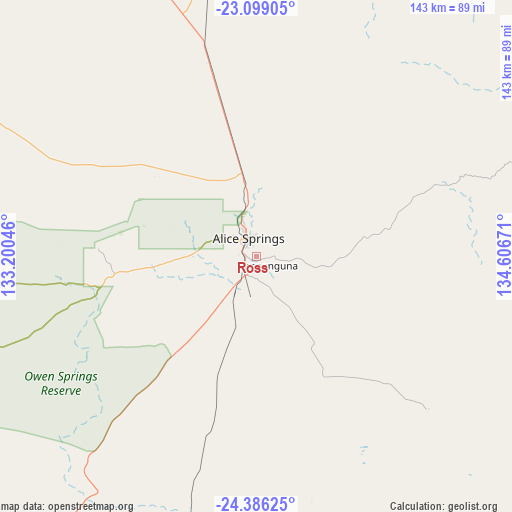
Ross GPS coordinates[2]
23° 44' 39.264" South, 133° 54' 12.888" East
| Map corner | latitude | longitude |
|---|---|---|
| Upper-left | -23.09905°, | 133.20046° |
| Center: | -23.74424°, | 133.90358° |
| Lower-right: | -24.38625°, | 134.60671° |
| Map W x H: | 143.1×143.1 km | = 88.9×88.9mi |
| max Lat: | -10.58257° ⇑8.9% North |
| Ross: | -23.74424° |
| min Lat: | ⇓91.1% South -43.31423° |
| min Long | Ross | max Long |
| 113.53327° | 133.90358° | 153.61246° |
| W 13.5%⇐ | ⇒86.5% E |
Elevation
Elevation of Ross is 580 m = 1903 ft, and this is 458 m = 1503 ft above average elevation for this country.
| Max E: |
1715 m = 5627 ft | 5.1% |
| Ross | 580 m 1903 ft | |
| Avg. | 122 m = 400 ft | |
Min E: |
-2 m = -7 ft | 94.9% |
See also: Australia elevation on elevation.city.
Geographical zone
Ross is located in South temperate zone (between Tropic of Capricorn and the Antarctic Circle). Distance of this Southern Tropic circle is 34.2 km =21.3 mi to North.| Distance of | km | miles | from Ross |
|---|---|---|---|
| Equator | 2640.1 | 1640.5 | to North |
| Tropic Capricorn | 34.2 | 21.3 | to North |
| Antarctic Circle | 4761.1 | 2958.4 | to South |
| South Pole | 7366.9 | 4577.6 | to South |


Nearby cities:
15 places around Ross: (largest is in red/bold)
• Alice Springs
5.6 km =3.5 mi,  338°
338°
• Alice Springs city centre
5.7 km =3.5 mi, 337°
• Araluen
7.4 km =4.6 mi,  316°
316°
• Braitling
8 km =5 mi,  333°
333°
• Desert Springs
3.6 km =2.2 mi, 333°
• East Side
5.9 km =3.7 mi,  349°
349°
• Gillen
5.5 km =3.4 mi, 315°
• Hermannsburg
116.6 km =72.5 mi,  258°
258°
• Hugh
70.3 km =43.7 mi,  209°
209°
• Ilparpa
8.8 km =5.5 mi, 264°
• Larapinta
9.3 km =5.8 mi,  307°
307°
• Mount Johns
2.5 km =1.6 mi,  22°
22°
• Sadadeen
4.5 km =2.8 mi,  355°
355°
• Santa Teresa
64.2 km =39.9 mi,  131°
131°
• The Gap
4.6 km =2.9 mi, 318°
Sources, notices
• [Note1] Compared only with cities in Australia existing in our database
• [Src1] Map data: © OpenStreetMap contributors (CC-BY-SA)
• [Src2] Other city data from geonames.org with taken over terms of usage.
• [Src3] Geographical zone / Annual Mean Temperature by Robert A. Rohde @ Wikipedia
