Larapinta geodata
Larapinta (Northern Territory) is a section of populated place; located in Australia in Australia/Darwin (GMT+9.5) time zone. With population of 2,159 people, there are 2789 cities with bigger population in this country. Compared to other cities in Australia, 91.3% of cities are located further ↓South; 86.7% of cities are located further →East and 95.7% of cities have lower elevation than Larapinta. Note1


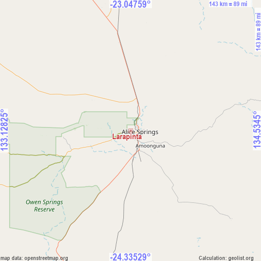
Larapinta GPS coordinates[2]
23° 41' 34.908" South, 133° 49' 52.932" East
| Map corner | latitude | longitude |
|---|---|---|
| Upper-left | -23.04759°, | 133.12825° |
| Center: | -23.69303°, | 133.83137° |
| Lower-right: | -24.33529°, | 134.5345° |
| Map W x H: | 143.2×143.2 km | = 89×89mi |
| max Lat: | -10.58257° ⇑8.7% North |
| Larapinta: | -23.69303° |
| min Lat: | ⇓91.3% South -43.31423° |
| min Long | Larapinta | max Long |
| 113.53327° | 133.83137° | 153.61246° |
| W 13.3%⇐ | ⇒86.7% E |
Elevation
Elevation of Larapinta is 597 m = 1959 ft, and this is 475 m = 1558 ft above average elevation for this country.
| Max E: |
1715 m = 5627 ft | 4.3% |
| Larapinta | 597 m 1959 ft | |
| Avg. | 122 m = 400 ft | |
Min E: |
-2 m = -7 ft | 95.7% |
See also: Australia elevation on elevation.city.
Geographical zone
Larapinta is located in South temperate zone (between Tropic of Capricorn and the Antarctic Circle). Distance of this Southern Tropic circle is 28.5 km =17.7 mi to North.| Distance of | km | miles | from Larapinta |
|---|---|---|---|
| Equator | 2634.4 | 1636.9 | to North |
| Tropic Capricorn | 28.5 | 17.7 | to North |
| Antarctic Circle | 4766.8 | 2962 | to South |
| South Pole | 7372.6 | 4581.1 | to South |


Nearby cities:
15 places around Larapinta: (largest is in red/bold)
• Alice Springs
5.3 km =3.3 mi,  95°
95°
• Alice Springs city centre
5.1 km =3.2 mi,  94°
94°
• Araluen
2.3 km =1.4 mi, 98°
• Braitling
4.1 km =2.5 mi,  69°
69°
• Desert Springs
6.3 km =3.9 mi,  113°
113°
• East Side
6.3 km =3.9 mi, 88°
• Gillen
4 km =2.5 mi,  116°
116°
• Hermannsburg
110.8 km =68.8 mi,  255°
255°
• Hugh
72.2 km =44.9 mi,  202°
202°
• Ilparpa
6.7 km =4.2 mi,  191°
191°
• Mount Johns
9 km =5.6 mi, 111°
• Ross
9.3 km =5.8 mi,  127°
127°
• Sadadeen
7.1 km =4.4 mi, 99°
• Santa Teresa
73.5 km =45.7 mi, 131°
• The Gap
4.9 km =3 mi, 117°
Sources, notices
• [Note1] Compared only with cities in Australia existing in our database
• [Src1] Map data: © OpenStreetMap contributors (CC-BY-SA)
• [Src2] Other city data from geonames.org with taken over terms of usage.
• [Src3] Geographical zone / Annual Mean Temperature by Robert A. Rohde @ Wikipedia
