Araluen geodata
Araluen (Northern Territory) is a section of populated place; located in Australia in Australia/Darwin (GMT+9.5) time zone. With population of 2,820 people, there are 2367 cities with bigger population in this country. Compared to other cities in Australia, 91.3% of cities are located further ↓South; 86.7% of cities are located further →East and 96.1% of cities have lower elevation than Araluen. Note1


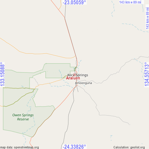
Araluen GPS coordinates[2]
23° 41' 45.636" South, 133° 51' 14.4" East
| Map corner | latitude | longitude |
|---|---|---|
| Upper-left | -23.05059°, | 133.15088° |
| Center: | -23.69601°, | 133.854° |
| Lower-right: | -24.33826°, | 134.55713° |
| Map W x H: | 143.2×143.2 km | = 89×89mi |
| max Lat: | -10.58257° ⇑8.7% North |
| Araluen: | -23.69601° |
| min Lat: | ⇓91.3% South -43.31423° |
| min Long | Araluen | max Long |
| 113.53327° | 133.854° | 153.61246° |
| W 13.3%⇐ | ⇒86.7% E |
Elevation
Elevation of Araluen is 606 m = 1988 ft, and this is 484 m = 1588 ft above average elevation for this country.
| Max E: |
1715 m = 5627 ft | 3.9% |
| Araluen | 606 m 1988 ft | |
| Avg. | 122 m = 400 ft | |
Min E: |
-2 m = -7 ft | 96.1% |
See also: Australia elevation on elevation.city.
Geographical zone
Araluen is located in South temperate zone (between Tropic of Capricorn and the Antarctic Circle). Distance of this Southern Tropic circle is 28.8 km =17.9 mi to North.| Distance of | km | miles | from Araluen |
|---|---|---|---|
| Equator | 2634.7 | 1637.1 | to North |
| Tropic Capricorn | 28.8 | 17.9 | to North |
| Antarctic Circle | 4766.4 | 2961.7 | to South |
| South Pole | 7372.3 | 4580.9 | to South |


Nearby cities:
15 places around Araluen: (largest is in red/bold)
• Alice Springs
3 km =1.9 mi,  93°
93°
• Alice Springs city centre
2.8 km =1.7 mi, 92°
• Braitling
2.3 km =1.4 mi,  40°
40°
• Desert Springs
4.1 km =2.5 mi,  122°
122°
• East Side
4 km =2.5 mi,  83°
83°
• Gillen
1.9 km =1.2 mi,  140°
140°
• Hermannsburg
112.9 km =70.2 mi,  255°
255°
• Hugh
72.9 km =45.3 mi,  204°
204°
• Ilparpa
7.3 km =4.5 mi,  210°
210°
• Larapinta
2.3 km =1.4 mi,  278°
278°
• Mount Johns
6.7 km =4.2 mi, 116°
• Ross
7.4 km =4.6 mi, 136°
• Sadadeen
4.8 km =3 mi,  100°
100°
• Santa Teresa
71.6 km =44.5 mi,  132°
132°
• The Gap
2.8 km =1.7 mi, 133°
Sources, notices
• [Note1] Compared only with cities in Australia existing in our database
• [Src1] Map data: © OpenStreetMap contributors (CC-BY-SA)
• [Src2] Other city data from geonames.org with taken over terms of usage.
• [Src3] Geographical zone / Annual Mean Temperature by Robert A. Rohde @ Wikipedia
