Pinnaroo geodata
Pinnaroo (South Australia) is a populated place; located in Australia in Australia/Adelaide (GMT+10.5) time zone. With population of 720 people, there are 4292 cities with bigger population in this country. Compared to other cities in Australia, 75.1% of cities are located further ↑North; 75.4% of cities are located further →East and 71.7% of cities have lower elevation than Pinnaroo. Note1


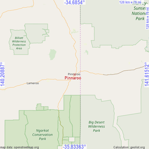
Pinnaroo GPS coordinates[2]
35° 15' 41.58" South, 140° 54' 43.164" East
| Map corner | latitude | longitude |
|---|---|---|
| Upper-left | -34.6854°, | 140.20887° |
| Center: | -35.26155°, | 140.91199° |
| Lower-right: | -35.83363°, | 141.61512° |
| Map W x H: | 127.7×127.7 km | = 79.3×79.3mi |
| max Lat: | -10.58257° ⇑75.1% North |
| Pinnaroo: | -35.26155° |
| min Lat: | ⇓24.9% South -43.31423° |
| min Long | Pinnaroo | max Long |
| 113.53327° | 140.91199° | 153.61246° |
| W 24.6%⇐ | ⇒75.4% E |
Elevation
Elevation of Pinnaroo is 111 m = 364 ft, and this is 11 m = 36 ft below average elevation for this country.
| Max E: |
1715 m = 5627 ft | 28.3% |
| Avg. | 122 m = 400 ft | |
| Pinnaroo | 111 m = 364 ft | |
Min E: |
-2 m = -7 ft | 71.7% |
See also: Australia elevation on elevation.city.
Geographical zone
Pinnaroo is located in South temperate zone (between Tropic of Capricorn and the Antarctic Circle). Distance of this Southern Tropic circle is 1314.8 km =817 mi to North.| Distance of | km | miles | from Pinnaroo |
|---|---|---|---|
| Equator | 3920.7 | 2436.2 | to North |
| Tropic Capricorn | 1314.8 | 817 | to North |
| Antarctic Circle | 3480.5 | 2162.7 | to South |
| South Pole | 6086.3 | 3781.9 | to South |


Nearby cities:
15 places around Pinnaroo: (largest is in red/bold)
• Barmera
119.2 km =74.1 mi,  339°
339°
• Berri
112.7 km =70 mi,  345°
345°
• Bordertown
117 km =72.7 mi,  186°
186°
• Glossop
114.6 km =71.2 mi, 342°
• Karoonda
94.4 km =58.7 mi,  281°
281°
• Keith
105.9 km =65.8 mi,  208°
208°
• Lameroo
36.6 km =22.7 mi,  258°
258°
• Loveday
117.2 km =72.8 mi, 338°
• Loxton
95.5 km =59.3 mi, 340°
• Loxton North
97.6 km =60.6 mi, 344°
• Monash
118.2 km =73.4 mi, 344°
• Paringa
121.2 km =75.3 mi, 354°
• Rainbow
120.9 km =75.1 mi,  125°
125°
• Renmark
121.5 km =75.5 mi, 352°
• Tintinara
104 km =64.6 mi,  228°
228°
Sources, notices
• [Note1] Compared only with cities in Australia existing in our database
• [Src1] Map data: © OpenStreetMap contributors (CC-BY-SA)
• [Src2] Other city data from geonames.org with taken over terms of usage.
• [Src3] Geographical zone / Annual Mean Temperature by Robert A. Rohde @ Wikipedia
