Pink Lake geodata
Pink Lake (Western Australia) is a section of populated place; located in Australia in Australia/Perth (GMT+8) time zone. With population of 890 people, there are 3989 cities with bigger population in this country. Compared to other cities in Australia, 53.8% of cities are located further ↑North; 89% of cities are located further →East and 90.1% of cities have higher elevation than Pink Lake. Note1


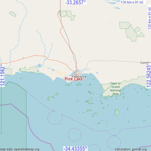
Pink Lake GPS coordinates[2]
33° 51' 5.832" South, 121° 51' 33.552" East
| Map corner | latitude | longitude |
|---|---|---|
| Upper-left | -33.2657°, | 121.1562° |
| Center: | -33.85162°, | 121.85932° |
| Lower-right: | -34.43355°, | 122.56245° |
| Map W x H: | 129.9×129.9 km | = 80.7×80.7mi |
| max Lat: | -10.58257° ⇑53.8% North |
| Pink Lake: | -33.85162° |
| min Lat: | ⇓46.2% South -43.31423° |
| min Long | Pink Lake | max Long |
| 113.53327° | 121.85932° | 153.61246° |
| W 11%⇐ | ⇒89% E |
Elevation
Elevation of Pink Lake is 9 m = 30 ft, and this is 113 m = 371 ft below average elevation for this country.
| Max E: |
1715 m = 5627 ft | 90.1% |
| Avg. | 122 m = 400 ft | |
| Pink Lake | 9 m = 30 ft | |
Min E: |
-2 m = -7 ft | 9.9% |
See also: Australia elevation on elevation.city.
Geographical zone
Pink Lake is located in South temperate zone (between Tropic of Capricorn and the Antarctic Circle). Distance of this Southern Tropic circle is 1158 km =719.5 mi to North.| Distance of | km | miles | from Pink Lake |
|---|---|---|---|
| Equator | 3763.9 | 2338.8 | to North |
| Tropic Capricorn | 1158 | 719.5 | to North |
| Antarctic Circle | 3637.2 | 2260.1 | to South |
| South Pole | 6243.1 | 3879.3 | to South |


Nearby cities:
15 places around Pink Lake: (largest is in red/bold)
• Boulder
343.1 km =213.2 mi,  354°
354°
• Broadwood
342.5 km =212.8 mi, 353°
• Castletown
5.6 km =3.5 mi,  67°
67°
• Coolgardie
328.9 km =204.4 mi, 348°
• Esperance
3.1 km =1.9 mi,  105°
105°
• Hopetoun
160.3 km =99.6 mi,  266°
266°
• Kambalda East
294.8 km =183.2 mi,  356°
356°
• Kambalda West
295.4 km =183.6 mi, 355°
• Lake Grace
325.6 km =202.3 mi,  284°
284°
• Norseman
184.1 km =114.4 mi, 357°
• Nulsen
1.6 km =1 mi, 112°
• Ravensthorpe
170.3 km =105.8 mi, 280°
• Sinclair
1.8 km =1.1 mi,  138°
138°
• Stoneville
332 km =206.3 mi, 358°
• West Beach
3.8 km =2.4 mi,  131°
131°
Sources, notices
• [Note1] Compared only with cities in Australia existing in our database
• [Src1] Map data: © OpenStreetMap contributors (CC-BY-SA)
• [Src2] Other city data from geonames.org with taken over terms of usage.
• [Src3] Geographical zone / Annual Mean Temperature by Robert A. Rohde @ Wikipedia
