Karratha Industrial Estate geodata
Karratha Industrial Estate (Western Australia) is a populated place; located in Australia in Australia/Perth (GMT+8) time zone. With population of 644 people, there are 4460 cities with bigger population in this country. Compared to other cities in Australia, 93.7% of cities are located further ↓South; 90.6% of cities are located further →East and 81.9% of cities have higher elevation than Karratha Industrial Estate. Note1
Current local time in Karratha Industrial Estate:
10:00 AM, ThursdayDifference from your time zone: hours


Karratha Industrial Estate GPS coordinates[2]
20° 46' 17.904" South, 116° 52' 9.768" East
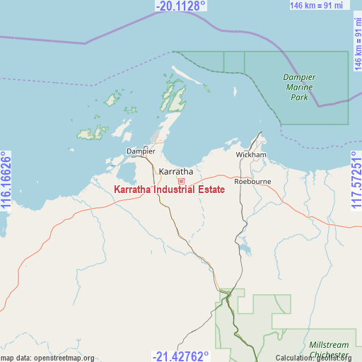
| Map corner | latitude | longitude |
|---|---|---|
| Upper-left | -20.1128°, | 116.16626° |
| Center: | -20.77164°, | 116.86938° |
| Lower-right: | -21.42762°, | 117.57251° |
| Map W x H: | 146.2×146.2 km | = 90.8×90.8mi |
| max Lat: | -10.58257° ⇑6.3% North |
| Karratha Industrial Estate: | -20.77164° |
| min Lat: | ⇓93.7% South -43.31423° |
| min Long | Karratha Indust | max Long |
| 113.53327° | 116.86938° | 153.61246° |
| W 9.4%⇐ | ⇒90.6% E |
Elevation
Elevation of Karratha Industrial Estate is 14 m = 46 ft, and this is 108 m = 354 ft below average elevation for this country.
| Max E: |
1715 m = 5627 ft | 81.9% |
| Avg. | 122 m = 400 ft | |
| Karratha Industrial Estate | 14 m = 46 ft | |
Min E: |
-2 m = -7 ft | 18.1% |
See also: Australia elevation on elevation.city.
Geographical zone
Karratha Industrial Estate is located in South Torrid zone (between Equator and Tropic of Capricorn). Distance of this Southern Tropic circle is 296.3 km =184.1 mi to South.| Distance of | km | miles | from Karratha Industrial Estate |
|---|---|---|---|
| Equator | 2309.6 | 1435.1 | to North |
| Tropic Capricorn | 296.3 | 184.1 | to South |
| Antarctic Circle | 5091.6 | 3163.8 | to South |
| South Pole | 7697.5 | 4783 | to South |


Nearby cities:
15 places around Karratha Industrial Estate: (largest is in red/bold)
• Baynton
7.4 km =4.6 mi,  287°
287°
• Bulgarra
5.3 km =3.3 mi,  345°
345°
• Dampier
20.3 km =12.6 mi,  306°
306°
• Karratha
4.5 km =2.8 mi,  327°
327°
• Millars Well
6.4 km =4 mi,  301°
301°
• Nickol
8.2 km =5.1 mi, 290°
• Onslow
206 km =128 mi,  242°
242°
• Pannawonica
111.9 km =69.5 mi,  210°
210°
• Paraburdoo
282.8 km =175.7 mi,  163°
163°
• Pegs Creek
5.3 km =3.3 mi, 314°
• Port Hedland
188.4 km =117.1 mi,  74°
74°
• Roebourne
28.8 km =17.9 mi,  90°
90°
• South Hedland
184.7 km =114.8 mi,  77°
77°
• Tom Price
234.1 km =145.5 mi, 155°
• Wickham
29.9 km =18.6 mi, 68°
Sources, notices
• [Note1] Compared only with cities in Australia existing in our database
• [Src1] Map data: © OpenStreetMap contributors (CC-BY-SA)
• [Src2] Other city data from geonames.org with taken over terms of usage.
• [Src3] Geographical zone / Annual Mean Temperature by Robert A. Rohde @ Wikipedia
