Bulgarra geodata
Bulgarra (Western Australia) is a section of populated place; located in Australia in Australia/Perth (GMT+8) time zone. With population of 3,035 people, there are 2236 cities with bigger population in this country. Compared to other cities in Australia, 94% of cities are located further ↓South; 90.7% of cities are located further →East and 93.8% of cities have higher elevation than Bulgarra. Note1


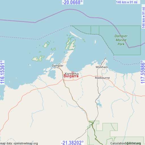
Bulgarra GPS coordinates[2]
20° 43' 33.024" South, 116° 51' 24.228" East
| Map corner | latitude | longitude |
|---|---|---|
| Upper-left | -20.0668°, | 116.15361° |
| Center: | -20.72584°, | 116.85673° |
| Lower-right: | -21.38202°, | 117.55986° |
| Map W x H: | 146.2×146.2 km | = 90.8×90.8mi |
| max Lat: | -10.58257° ⇑6% North |
| Bulgarra: | -20.72584° |
| min Lat: | ⇓94% South -43.31423° |
| min Long | Bulgarra | max Long |
| 113.53327° | 116.85673° | 153.61246° |
| W 9.3%⇐ | ⇒90.7% E |
Elevation
Elevation of Bulgarra is 7 m = 23 ft, and this is 115 m = 377 ft below average elevation for this country.
| Max E: |
1715 m = 5627 ft | 93.8% |
| Avg. | 122 m = 400 ft | |
| Bulgarra | 7 m = 23 ft | |
Min E: |
-2 m = -7 ft | 6.2% |
See also: Australia elevation on elevation.city.
Geographical zone
Bulgarra is located in South Torrid zone (between Equator and Tropic of Capricorn). Distance of this Southern Tropic circle is 301.4 km =187.3 mi to South.| Distance of | km | miles | from Bulgarra |
|---|---|---|---|
| Equator | 2304.5 | 1431.9 | to North |
| Tropic Capricorn | 301.4 | 187.3 | to South |
| Antarctic Circle | 5096.7 | 3166.9 | to South |
| South Pole | 7702.6 | 4786.2 | to South |


Nearby cities:
15 places around Bulgarra: (largest is in red/bold)
• Baynton
6.4 km =4 mi,  243°
243°
• Dampier
16.6 km =10.3 mi,  295°
295°
• Karratha
1.7 km =1.1 mi,  219°
219°
• Karratha Industrial Estate
5.3 km =3.3 mi,  165°
165°
• Millars Well
4.5 km =2.8 mi,  246°
246°
• Nickol
6.7 km =4.2 mi, 251°
• Onslow
207.3 km =128.8 mi, 240°
• Pannawonica
115.7 km =71.9 mi,  208°
208°
• Paraburdoo
288 km =179 mi,  163°
163°
• Pegs Creek
2.8 km =1.7 mi, 240°
• Port Hedland
188.3 km =117 mi,  75°
75°
• Roebourne
30.6 km =19 mi,  99°
99°
• South Hedland
185 km =115 mi, 78°
• Tom Price
239.3 km =148.7 mi, 156°
• Wickham
29.8 km =18.5 mi, 79°
Sources, notices
• [Note1] Compared only with cities in Australia existing in our database
• [Src1] Map data: © OpenStreetMap contributors (CC-BY-SA)
• [Src2] Other city data from geonames.org with taken over terms of usage.
• [Src3] Geographical zone / Annual Mean Temperature by Robert A. Rohde @ Wikipedia
