Kyzyl-Burun geodata
Kyzyl-Burun (Siyǝzǝn) is a seat of a first-order administrative division; located in Azerbaijan in Asia/Baku (GMT+4) time zone. With population of 3 people, there are 182 cities with bigger population in this country. Compared to other cities in Azerbaijan, 86.5% of cities are located further ↓South; 75.1% of cities are located further ←West and 76.8% of cities have higher elevation than Kyzyl-Burun. Note1


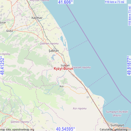
Kyzyl-Burun GPS coordinates[2]
41° 4' 41.196" North, 49° 6' 56.304" East
| Map corner | latitude | longitude |
|---|---|---|
| Upper-left | 41.606°, | 48.41252° |
| Center: | 41.07811°, | 49.11564° |
| Lower-right: | 40.54595°, | 49.81877° |
| Map W x H: | 117.9×117.9 km | = 73.3×73.3mi |
| max Lat: | 41.75259° ⇑13.5% North |
| Kyzyl-Burun: | 41.07811° |
| min Lat: | ⇓86.5% South 38.45598° |
| min Long | Kyzyl-Burun | max Long |
| 44.84846° | 49.11564° | 50.84003° |
| W 75.1%⇐ | ⇒24.9% E |
Elevation
Elevation of Kyzyl-Burun is 13 m = 43 ft, and this is 370 m = 1214 ft below average elevation for this country.
| Max E: |
2211 m = 7254 ft | 76.8% |
| Avg. | 383 m = 1257 ft | |
| Kyzyl-Burun | 13 m = 43 ft | |
Min E: |
-26 m = -85 ft | 23.2% |
See also: Azerbaijan elevation on elevation.city.
Geographical zone
Kyzyl-Burun is located in North temperate zone (between Tropic of Cancer and the Arctic Circle). Distance of this Northern Tropic circle is 1961.5 km =1218.8 mi to South.| Distance of | km | miles | from Kyzyl-Burun |
|---|---|---|---|
| North Pole | 5439.6 | 3380 | to North |
| Arctic Circle | 2833.7 | 1760.8 | to North |
| Tropic Cancer | 1961.5 | 1218.8 | to South |
| Equator | 4567.5 | 2838.1 | to South |


Nearby cities:
15 places around Kyzyl-Burun: (largest is in red/bold)
• Altıağac
28.8 km =17.9 mi,  211°
211°
• Basqal
70.7 km =43.9 mi,  239°
239°
• Divichibazar
17.4 km =10.8 mi,  321°
321°
• Gilgilçay
7.1 km =4.4 mi,  342°
342°
• Hacı Zeynalabdin
62.8 km =39 mi,  143°
143°
• Hacıhüseynli
57.4 km =35.7 mi, 317°
• Khyzy
19.2 km =11.9 mi,  190°
190°
• Kilyazi
29.7 km =18.5 mi, 139°
• Lahıc
66.8 km =41.5 mi,  247°
247°
• Qobustan
62.6 km =38.9 mi, 194°
• Quba
59.4 km =36.9 mi,  301°
301°
• Qusar
69.2 km =43 mi, 304°
• Shamakhi
63.7 km =39.6 mi,  218°
218°
• Xaçmaz
50.1 km =31.1 mi,  328°
328°
• Şuraabad
41.2 km =25.6 mi,  134°
134°
Sources, notices
• [Note1] Compared only with cities in Azerbaijan existing in our database
• [Src1] Map data: © OpenStreetMap contributors (CC-BY-SA)
• [Src2] Other city data from geonames.org with taken over terms of usage.
• [Src3] Geographical zone / Annual Mean Temperature by Robert A. Rohde @ Wikipedia
