Yukhary-Dashkesan geodata
Yukhary-Dashkesan (Daşkǝsǝn) is a seat of a first-order administrative division; located in Azerbaijan in Asia/Baku (GMT+4) time zone. With population of 9,900 people, there are 73 cities with bigger population in this country. Compared to other cities in Azerbaijan, 59.5% of cities are located further ↓South; 78.9% of cities are located further →East and 98.4% of cities have lower elevation than Yukhary-Dashkesan. Note1


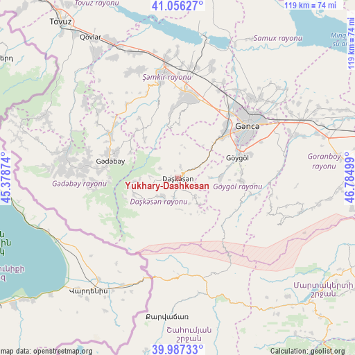
Yukhary-Dashkesan GPS coordinates[2]
40° 31' 26.148" North, 46° 4' 54.696" East
| Map corner | latitude | longitude |
|---|---|---|
| Upper-left | 41.05627°, | 45.37874° |
| Center: | 40.52393°, | 46.08186° |
| Lower-right: | 39.98733°, | 46.78499° |
| Map W x H: | 118.9×118.9 km | = 73.9×73.9mi |
| max Lat: | 41.75259° ⇑40.5% North |
| Yukhary-Dashkesan: | 40.52393° |
| min Lat: | ⇓59.5% South 38.45598° |
| min Long | Yukhary-Dashkes | max Long |
| 44.84846° | 46.08186° | 50.84003° |
| W 21.1%⇐ | ⇒78.9% E |
Elevation
Elevation of Yukhary-Dashkesan is 1601 m = 5253 ft, and this is 1218 m = 3996 ft above average elevation for this country.
| Max E: |
2211 m = 7254 ft | 1.6% |
| Yukhary-Dashkesan | 1601 m 5253 ft | |
| Avg. | 383 m = 1257 ft | |
Min E: |
-26 m = -85 ft | 98.4% |
See also: Azerbaijan elevation on elevation.city.
Geographical zone
Yukhary-Dashkesan is located in North temperate zone (between Tropic of Cancer and the Arctic Circle). Distance of this Northern Tropic circle is 1899.9 km =1180.5 mi to South.| Distance of | km | miles | from Yukhary-Dashkesan |
|---|---|---|---|
| North Pole | 5501.2 | 3418.3 | to North |
| Arctic Circle | 2895.3 | 1799.1 | to North |
| Tropic Cancer | 1899.9 | 1180.5 | to South |
| Equator | 4505.8 | 2799.8 | to South |


Nearby cities:
15 places around Yukhary-Dashkesan: (largest is in red/bold)
• Alunitdağ
2.6 km =1.6 mi,  284°
284°
• Arıqdam
25.1 km =15.6 mi,  287°
287°
• Arıqıran
39.6 km =24.6 mi,  272°
272°
• Böyük Qaramurad
38 km =23.6 mi, 278°
• Dolyar
37.9 km =23.5 mi,  354°
354°
• Ganja
29.4 km =18.3 mi,  53°
53°
• Kyadabek
23.4 km =14.5 mi, 282°
• Novosaratovka
41.5 km =25.8 mi, 281°
• Qarayeri
35.2 km =21.9 mi,  33°
33°
• Qasım İsmayılov
35.4 km =22 mi, 25°
• Samux
38.4 km =23.9 mi, 45°
• Shamkhor
34.4 km =21.4 mi, 350°
• Verkhniy Dashkesan
3.5 km =2.2 mi,  194°
194°
• Yelenendorf
21.2 km =13.2 mi,  71°
71°
• Çobansığnaq
40.6 km =25.2 mi,  308°
308°
Sources, notices
• [Note1] Compared only with cities in Azerbaijan existing in our database
• [Src1] Map data: © OpenStreetMap contributors (CC-BY-SA)
• [Src2] Other city data from geonames.org with taken over terms of usage.
• [Src3] Geographical zone / Annual Mean Temperature by Robert A. Rohde @ Wikipedia
