Sātkhira geodata
Sātkhira (Khulna) is a populated place; located in Bangladesh in Asia/Dhaka (GMT+6) time zone. With population of 128,918 people, there are 30 cities with bigger population in this country. Compared to other cities in Bangladesh, 82.1% of cities are located further ↑North; 83.8% of cities are located further →East and 76.1% of cities have higher elevation than Sātkhira. Note1
Administrative division(s):
- Level 1: Khulna
- Level 2: Satkhira
- Level 3: Satkhira S.
- Level 4: Paurashava


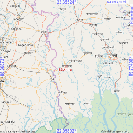
Sātkhira GPS coordinates[2]
22° 42' 29.412" North, 89° 4' 18.66" East
| Map corner | latitude | longitude |
|---|---|---|
| Upper-left | 23.35524°, | 88.36873° |
| Center: | 22.70817°, | 89.07185° |
| Lower-right: | 22.05802°, | 89.77498° |
| Map W x H: | 144.2×144.2 km | = 89.6×89.6mi |
| max Lat: | 26.33338° ⇑82.1% North |
| Sātkhira: | 22.70817° |
| min Lat: | ⇓17.9% South 20.85829° |
| min Long | Sātkhira | max Long |
| 88.15638° | 89.07185° | 92.29773° |
| W 16.2%⇐ | ⇒83.8% E |
Elevation
Elevation of Sātkhira is 11 m = 36 ft, and this is 6.9 m = 23 ft below average elevation for this country.
| Max E: |
79 m = 259 ft | 76.1% |
| Avg. | 17.9 m = 59 ft | |
| Sātkhira | 11 m = 36 ft | |
Min E: |
2 m = 7 ft | 23.9% |
See also: Sātkhira elevation on elevation.city.
Geographical zone
Sātkhira is located in North Torrid zone (between Equator and Tropic of Cancer). Distance of this Northern Tropic circle is 81 km =50.3 mi to North.| Distance of | km | miles | from Sātkhira |
|---|---|---|---|
| North Pole | 7482.2 | 4649.2 | to North |
| Arctic Circle | 4876.3 | 3030 | to North |
| Tropic Cancer | 81 | 50.3 | to North |
| Equator | 2524.9 | 1568.9 | to South |


Nearby cities:
15 places around Sātkhira: (largest is in red/bold)
• Bagerhat
74 km =46 mi,  94°
94°
• Bhātpāra Abhaynagar
50.8 km =31.6 mi,  47°
47°
• Jessore
53.3 km =33.1 mi,  15°
15°
• Jhingergācha
44.9 km =27.9 mi,  2°
2°
• Kesabpur
26.8 km =16.7 mi,  34°
34°
• Khulna
51.7 km =32.1 mi,  77°
77°
• Kālia
68.3 km =42.4 mi,  56°
56°
• Kālīganj
78.3 km =48.7 mi, 4°
• Magura
93.5 km =58.1 mi, 22°
• Morrelgonj
85.2 km =52.9 mi,  109°
109°
• Narail
65.9 km =40.9 mi,  41°
41°
• Phultala
45.1 km =28 mi, 88°
• Pirojpur
93.8 km =58.3 mi,  98°
98°
• Sarankhola
86.1 km =53.5 mi,  120°
120°
• Tungipāra
87.8 km =54.6 mi, 75°
Sources, notices
• [Note1] Compared only with cities in Bangladesh existing in our database
• [Src1] Map data: © OpenStreetMap contributors (CC-BY-SA)
• [Src2] Other city data from geonames.org with taken over terms of usage.
• [Src3] Geographical zone / Annual Mean Temperature by Robert A. Rohde @ Wikipedia
