Bagerhat geodata
Bagerhat (Khulna) is a seat of a second-order administrative division; located in Bangladesh in Asia/Dhaka (GMT+6) time zone. With population of 266,388 people, there are 10 cities with bigger population in this country. Compared to other cities in Bangladesh, 85.5% of cities are located further ↑North; 62.4% of cities are located further →East and 98.3% of cities have higher elevation than Bagerhat. Note1
Administrative division(s):
- Level 1: Khulna
- Level 2: Bagerhat
- Level 3: Bagerhat S.
- Level 4: Paurashava


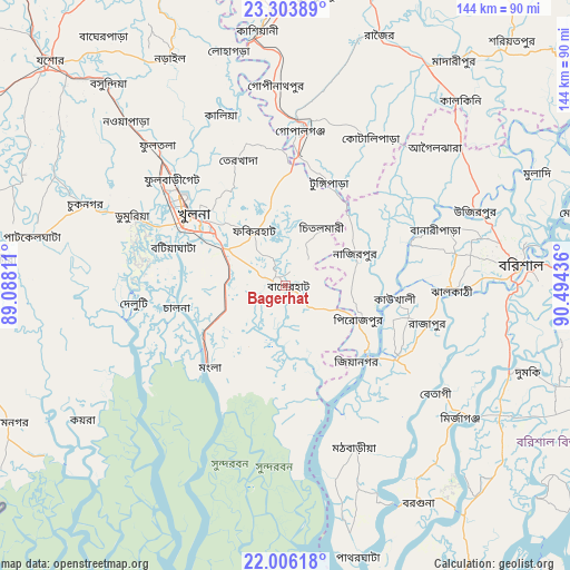
Bagerhat GPS coordinates[2]
22° 39' 23.652" North, 89° 47' 28.428" East
| Map corner | latitude | longitude |
|---|---|---|
| Upper-left | 23.30389°, | 89.08811° |
| Center: | 22.65657°, | 89.79123° |
| Lower-right: | 22.00618°, | 90.49436° |
| Map W x H: | 144.3×144.3 km | = 89.7×89.7mi |
| max Lat: | 26.33338° ⇑85.5% North |
| Bagerhat: | 22.65657° |
| min Lat: | ⇓14.5% South 20.85829° |
| min Long | Bagerhat | max Long |
| 88.15638° | 89.79123° | 92.29773° |
| W 37.6%⇐ | ⇒62.4% E |
Elevation
Elevation of Bagerhat is 7 m = 23 ft, and this is 10.9 m = 36 ft below average elevation for this country.
| Max E: |
79 m = 259 ft | 98.3% |
| Avg. | 17.9 m = 59 ft | |
| Bagerhat | 7 m = 23 ft | |
Min E: |
2 m = 7 ft | 1.7% |
See also: Bagerhat elevation on elevation.city.
Geographical zone
Bagerhat is located in North Torrid zone (between Equator and Tropic of Cancer). Distance of this Northern Tropic circle is 86.7 km =53.9 mi to North.| Distance of | km | miles | from Bagerhat |
|---|---|---|---|
| North Pole | 7487.9 | 4652.8 | to North |
| Arctic Circle | 4882 | 3033.5 | to North |
| Tropic Cancer | 86.7 | 53.9 | to North |
| Equator | 2519.2 | 1565.4 | to South |


Nearby cities:
15 places around Bagerhat: (largest is in red/bold)
• Barisāl
59.6 km =37 mi,  84°
84°
• Bhāndāria
33.5 km =20.8 mi,  123°
123°
• Bhātpāra Abhaynagar
53.7 km =33.4 mi,  317°
317°
• Gaurnadi
56.6 km =35.2 mi,  51°
51°
• Kesabpur
64.9 km =40.3 mi,  295°
295°
• Khulna
28.8 km =17.9 mi,  306°
306°
• Kālia
46 km =28.6 mi,  339°
339°
• Mathba
44.6 km =27.7 mi,  157°
157°
• Morrelgonj
23.3 km =14.5 mi, 163°
• Narail
63.2 km =39.3 mi,  331°
331°
• Nālchiti
49.4 km =30.7 mi,  92°
92°
• Phultala
29.4 km =18.3 mi,  283°
283°
• Pirojpur
20.7 km =12.9 mi,  114°
114°
• Sarankhola
38.5 km =23.9 mi,  180°
180°
• Tungipāra
29.4 km =18.3 mi,  23°
23°
Sources, notices
• [Note1] Compared only with cities in Bangladesh existing in our database
• [Src1] Map data: © OpenStreetMap contributors (CC-BY-SA)
• [Src2] Other city data from geonames.org with taken over terms of usage.
• [Src3] Geographical zone / Annual Mean Temperature by Robert A. Rohde @ Wikipedia
