Phultala geodata
Phultala (Khulna) is a populated place; located in Bangladesh in Asia/Dhaka (GMT+6) time zone. With population of 37,985 people, there are 86 cities with bigger population in this country. Compared to other cities in Bangladesh, 81.2% of cities are located further ↑North; 70.9% of cities are located further →East and 98.3% of cities have higher elevation than Phultala. Note1
Administrative division(s):
- Level 1: Khulna
- Level 2: Khulna
- Level 3: Batiaghata Upazila
- Level 4: Batiaghata


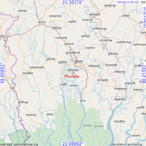
Phultala GPS coordinates[2]
22° 43' 0.228" North, 89° 30' 42.984" East
| Map corner | latitude | longitude |
|---|---|---|
| Upper-left | 23.36376°, | 88.80882° |
| Center: | 22.71673°, | 89.51194° |
| Lower-right: | 22.06662°, | 90.21507° |
| Map W x H: | 144.2×144.2 km | = 89.6×89.6mi |
| max Lat: | 26.33338° ⇑81.2% North |
| Phultala: | 22.71673° |
| min Lat: | ⇓18.8% South 20.85829° |
| min Long | Phultala | max Long |
| 88.15638° | 89.51194° | 92.29773° |
| W 29.1%⇐ | ⇒70.9% E |
Elevation
Elevation of Phultala is 7 m = 23 ft, and this is 10.9 m = 36 ft below average elevation for this country.
| Max E: |
79 m = 259 ft | 98.3% |
| Avg. | 17.9 m = 59 ft | |
| Phultala | 7 m = 23 ft | |
Min E: |
2 m = 7 ft | 1.7% |
See also: Bangladesh elevation on elevation.city.
Geographical zone
Phultala is located in North Torrid zone (between Equator and Tropic of Cancer). Distance of this Northern Tropic circle is 80.1 km =49.8 mi to North.| Distance of | km | miles | from Phultala |
|---|---|---|---|
| North Pole | 7481.2 | 4648.6 | to North |
| Arctic Circle | 4875.3 | 3029.4 | to North |
| Tropic Cancer | 80.1 | 49.8 | to North |
| Equator | 2525.9 | 1569.5 | to South |


Nearby cities:
15 places around Phultala: (largest is in red/bold)
• Bagerhat
29.4 km =18.3 mi,  103°
103°
• Bhāndāria
62 km =38.5 mi,  114°
114°
• Bhātpāra Abhaynagar
34 km =21.1 mi,  347°
347°
• Jessore
58.9 km =36.6 mi,  328°
328°
• Jhingergācha
61.5 km =38.2 mi,  315°
315°
• Kesabpur
36.7 km =22.8 mi,  305°
305°
• Khulna
11.7 km =7.3 mi,  27°
27°
• Kālia
38.3 km =23.8 mi,  18°
18°
• Mathba
66.3 km =41.2 mi,  136°
136°
• Morrelgonj
45.7 km =28.4 mi,  129°
129°
• Narail
48.8 km =30.3 mi,  357°
357°
• Pirojpur
49.9 km =31 mi, 107°
• Sarankhola
53.5 km =33.2 mi,  147°
147°
• Sātkhira
45.1 km =28 mi,  268°
268°
• Tungipāra
45 km =28 mi,  63°
63°
Sources, notices
• [Note1] Compared only with cities in Bangladesh existing in our database
• [Src1] Map data: © OpenStreetMap contributors (CC-BY-SA)
• [Src2] Other city data from geonames.org with taken over terms of usage.
• [Src3] Geographical zone / Annual Mean Temperature by Robert A. Rohde @ Wikipedia
